October 2013
Editorial
Dear friends,
In the course of our daily lives, we always lose something. These things may mean little to us at the time. But when these same items are found three centuries later, they take on a very different meaning! And so it was with Colin MacKinnon when he found a rusty metal fragment along the Missiguash River back in 2005. Read and learn about what Colin discovered around this lost piece of metal, especially when it potentially takes us back to the early 1600s in the life of the Tantramar region!
And then, when we were youngsters, we all had relatives who told us stories about various members of the family. But did we always listen? Sometimes… . Read Travis Tower’s story about his uncle Herb and Travis’s happy recollections of having listened to what uncle Herb had to say. Because, as Travis reminds us, oral history doesn’t always get written down… we just have to listen! Carefully! So looking down at the ground we walk on and listening carefully to those with a good story to tell us often captures bits of our history. And the Tantramar Heritage Trust, through your newsletter, is always out there looking to write it all down. I hope that you find the following stories as enjoyable to read as I did talking to Colin and Travis about them. Do you have any stories to tell? While you think about it, just read on and, hopefully, enjoy!
—Peter Hicklin
An early 17th Century “Snaphaunce” firearm lock recovered from the Missaquash Portage, NB
Text and photos by Colin M. MacKinnon
For untold centuries, travelers have canoed the waterways and traversed on foot along the narrow ridge of land at the head of the Missaguash River to the Baie Verte watersheds. This area, now the provincial border between Nova Scotia and New Brunswick, was the principal transportation and trade route across the Chignecto isthmus. As such, there were likely numerous resting points along the way. Based on the surviving evidence, some stopping places must have been used sparingly while others that contain native pottery are suggestive of more permanent camping sites. It is sad to think about how much history has been lost at such sites, either washed away or as yet undiscovered. Undoubtedly every turn in the river once carried an aboriginal name and associated story. When the French engineer Louis Franquet (1697–1768) travelled through the system in 1752, these names were already gone or at least not recorded. His map of this trip documents later European descriptions such as Pointe a la pipe and Lac a la tasse d’argent. Even the word Missaguash (an aboriginal name possibly referring to Muskrat) was nearly lost as, according to legend, Michelle Le Neuf, Sr. de la Vallière, who held the seigneurie for the area, changed the name to the River Marguerite after his daughter.
I suppose fortunate for historians, she became involved with a man of whom her father disapproved and the name was returned to Missaguash (Bird, 1928). A spot of particular interest along the navigation route is Black Island situated within the heart of the wetland (see MacKinnon and Colpitts, 2006). Marked as Île Verte on Franquet’s map, this place must have been of great spiritual significance to the area’s First People.
When M. de Muelles, the Intendant of Acadia, visited the region in 1686 and overwintered at Beaubassin, he conducted a census of the inhabitants. As part of this census, he reported that Michel LeNeuf Sr. de la Vallière, seigneur of Beaubassin, had not only his own armourer and gunsmith in residence (Me. Pertuis) but he also possessed 70 guns while an additional 32 were spread throughout the other inhabitants (de Muelles, 1686).

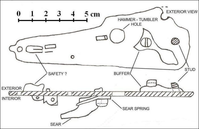
Figure 1: Exterior view of the Missaguash snaphaunce musket lock © Colin MacKinnon photo and sketch


Figure 2: Interior view of the Missaguash snaphaunce musket lock. © Colin MacKinnon photo and sketch
| Description | Measurement |
|---|---|
| *extrapolated original lock plate length of 229 mm (9″) as scaled to comparable examples | |
| Length of lock plate* | 128 mm |
| Width of lock plate | 43 mm |
| Thickness of lock plate | 3 mm |
| Length of Buffer | 35 mm |
| Hammer/Tumbler hole | 9 mm diameter |
| Rear retaining screw hole | 3 mm diameter |
| Top retaining screw hole | 5 mm diameter |
| Sear hole | 3 × 8 mm |
In 2005, I recovered the fragment of a rare and early “snaphaunce” firearm lock from along the Missaguash portage. The name “snaphaunce” derives from Dutch or German and refers to the action of the sparking mechanism. This fragment consists of only the rear half of a lock plate, the flat piece of metal on which the firing mechanism is attached (Figures 1 and 2). The lock has been damaged and bent with the forward portion of plate and mechanism having been sheared off. This could have been from past contact with a farming implement such as a plow, but this is purely speculation. The piece is severely corroded although portions of the lock sear, sear spring, hammer buffer and safety mechanism have survived. Measurements of the artifact and comparisons with other surviving examples suggest that the original intact lock could have been quite large (Table 1; see also Rimer 1987; Godwin, 1994; Gooding 1996).
It is noteworthy that this piece closely resembles the lock of a musket at Hardwick Hall in Derbyshire, England (see photograph by Michael Spencer in Godwin, 1994). The Hardwick Hall example resembles arms given by James I to Spain in 1604 (Lavin, 1992) and Godwin suggests a tentative date of circa 1610 to 1625. Recognizing that a study of these early mechanisms is particularly specialized, all I can suggest is that by visual comparison the Missaguash example appears very similar. The piece could have been functional for a considerable length of time as some snaphaunce were later converted and/or upgraded to the more conventional flintlock. It is also possible that the lock fragment is from a transitional piece, from snaphaunce to a more conventional flintlock. Sadly, so little has survived that it is hard to be absolutely certain. Even so, the artifact is still a scarce example of early weaponry. Surviving examples of the English-made snaphaunce are exceedingly rare. Brian Godwin, an authority of such guns, catalogued 70 examples of which only 9 were dated (Godwin, 1994). In North America, very few remnants have been reported with notable recoveries from Colonial Williamsburg, Virginia, and the “Colony of Avalon”, Ferryville, Newfoundland (the latter site was founded by George Calvert in 1621).

Figure 3: Example of an early 17th century snaphaunce lock mechanism —Colin MacKinnon sketch
In brief, firearms development just prior to this period included the “match-lock” (as can be seen in replicas at the Habitation at Port Royal), followed by the technologically-advanced (and thus expensive to make) “wheel lock” (Boothroyd, 1961). The latter was only owned by the very wealthy and, being a complicated mechanism, was difficult to maintain and not likely a common arm in North America. The next advancement was the “snaphaunce” (Figure 3), as discussed here, developed in the late 1500s and early 1600s. This was followed shortly after by various advancements in the flintlock mechanism. More-developed mid-18th century examples (the common British military version being referred to as the “Brown Bess”) are on display at the Museum at Fort Beausejour/Fort Cumberland. The lock fragment also enforces the value of provenance. On first impressions, a seemingly insignificant scrap of metal becomes an artifact of some importance. Once removed from its “in situ” location, and without documentation, the historical worth of an item becomes quickly lost (the exact location has been reported to the New Brunswick Department of Archaeological Services). One can easily imagine this artifact as once being a part of Sr. de la ValliËre’s personal arsenal, but we will never know for certain. How it came to be damaged and lost is also open to speculation. All sorts of scenarios are plausible: it may have once been a gift to a Mi’kmaq leader or a family heirloom in the possession of one of Chignecto’s Acadian families. If the latter, it could have been one of many possessions carried while fleeing the border region for Isle St. Jean (Prince Edward Island) and other destinations just prior to 1755. On this trek, only the most useful items would be retained with broken or obsolete accoutrements being discarded along the way.
In summary, we have here an example of an early and rare firearm mechanism from the Missaguash Portage. Although how it might have been deposited there is unknown, its presence and age supports the importance and antiquity of this centuries old navigation route. The lock, and thus the firearm it has survived from, would have pre-dated the beginning of the settlement of Beaubassin by 50 to 75 years and must be one of the earliest European manufactured implements recovered so far from the Chignecto isthmus.
Acknowledgements
A special thanks to Nancy and family for supporting my many interests. The late Geoffrey Boothroyd (armorer to “James Bond”) graciously responded to many queries over the years while the late James Gooding echoed the significance and rarity of the snaphaunce lock fragment under discussion and suggested its existence be made known to a wider audience. I would also like to thank Don Colpitts for his assistance as we tramped or paddled over much of the Tantramar, often in company with my sons Andrew and Neil, while chasing elusive stories and pondering the regions early history.
References
- Bird, Will R. 1928. A Century at Chignecto: the key to old Acadia.
- Boothroyd, Geoffrey. 1961. Guns Through the Ages. Bonanza Books, New York, USA.
- Lavin, J.D. 1992. The Gift of James I to Felipe of Spain. Journal of the Arms and Armour Society. Vol. XIV (2): 83
- Godwin, Brian C. 1994. The English Snaphaunce — some newly discovered examples. Arms Collecting, Vol. 32 (4): 121–124.
- Gooding, S. James. 1996. The Snaphaunce Muskets of al-Maghreb al Aqsa. Arms Collecting, Vol. 32 (3): 87–90. MacKinnon, C. M. and D. Colpitts 2006. The Black Island Knife; a proto-historic copper artifact from the Missaquash Marsh.The White Fence, Newsletter of the Tantramar Heritage Trust, Sackville, NB, Issue #31, Feb., 2006.
- Rimer, Graeme. 1987. The Typology of 17th Century Flintlocks in the Popham Armoury at Littlecote House. Arms Collecting, Vol. 25 (4): 122–123.
- De Meulles. 1686. Intendant of New France, Census of all the People of Beaubassin, RiviËre St-Jean, Port-Royal, Isle PersÈe and other Colonies of Acadia where he himself visited all of the Habitations at the beginning of the year 1686.
- acadian-home.org/census1686.html (Accessed 15 February, 2013)
The Serendipity of History (Part 1)
“…remember the McHafee lot…”
by Travis Tower
More often than not, we find things we weren’t looking for while searching for something entirely different, and sometimes — just sometimes — these discoveries unlock a chapter of history all but forgotten. The discovery of the 1808 boundary line between Lots B and C in Rockport, New Brunswick, came about by accident; an accident that taught a lesson we can all learn from.
Learning the importance of oral history is critical to preserving stories and events that might otherwise be lost, a fact to which I can now attest. As a young boy, my great, great uncle Herb would take my cousin and myself for routine trips to Rockport, NB, and more often than not this required visiting family and friends where times of another era were discussed and reminisced. Not the sort of thing that really interests young boys, though somehow it was always fun to be with him on these short trips. On a few occasions while returning from Rockport, my uncle Herb would pull over his pickup truck and stop by a parcel of property and when we inquired why we stopping here he said “This is the McHafee lot”. And then he would seem to drift off into thought and, after a few moments of reflection, he said “I don’t know who owns this now”. He sat there staring out the window lost in thought, which was only broken by two young, impatient boys nagging to get going. He then responded by saying “You need to remember the McHafee lot; it explains where everything else is located”. Now there is no way I would have ever remembered this had he not done this same thing on more than one occasion. When I think about this now, I wonder if he achieved his goal of getting us to remember this information or not?
Twenty five-plus years would pass and the importance of the McHafee lot was all but a lost memory tucked far away in the recesses of my memory. It would take an unexpected event that would start a chain reaction that would ultimately lead me to realize the importance of oral history.
The unexpected event was a land encroachment issue initiated by a third party on a piece of property owned by my family and located at Green Creek. My brother Herb was quick to say: “you remember uncle Herb telling us where the property lines were located”. I respond: “yes I do; however, he is not here to state this or explain why everything is as it is”. Moreover, I explained to my brother Herb that neither his opinion nor mine of where the boundary lines are located were of much use. We required facts to substantiate what we were saying. My brother’s solution was to get a local surveyor to assist and it was this event alone that set in motion the events that followed.

1808 Grant Map: The forty four acre lots in the Divisions Letter B and Letter C in Rockport
The local surveyor visited the area in question and discussed his findings with my brother Herb. As well, he gave my brother a section of the 1808 Grant Map of this area with some notes on it. Herb showed me the section of the grant map with the notes and it was these notes that caught my attention. The local surveyor had written names on some of the grant lots (see the 1808 Grant Map below). I asked my brother Herb about how the surveyor knew that these names corresponded with these grant lots. My brother Herb had no answer to this.
Seeking an answer as to how the local surveyor knew who owned which lots led me to seek the advice of a colleague at work, Colin MacKinnon, who is rather knowledgeable of the area to say the least. Colin explained that if you follow the chain of title of a property back far enough, it should reveal an associated grant number. However, Colin warned me that properties sometimes transferred hands without a new deed being written or registered — which can hinder a search. Colin also explained that sometimes property was sold with little or no reference to where it came from. Then Colin said: “like all things, you need to find one piece of the puzzle and the rest will fall into place”. Furthermore, he said that there must be one piece of property that has not changed hands often and has well-established boundaries.
The only property I could think of with well-established boundaries that hadn’t changed hands often was Arthur McCreedy’s property nearby at Johnson’s Mills. This knowledge served two purposes: one, it revealed a grant number associated with a property, and two, it revealed a physical property boundary line associated with this grant number. Why was this important? Well, with this information it was possible to locate the 1808 Grant Map division line separating lots in B and C division in Rockport. This line went from one side the peninsula to the other, from Johnson’s Mills to Rockport. How was this done? With rough GPS coordinates of Arthur McCreedy’s property line, I was able to locate where the location of the division line should be — which by chance was located on a piece of property of an acquaintance of mine, Brian King, who knew this area well and had a camp at this location.
Next, I paid Brian a visit at his camp and inquired if he knew where his boundaries were; he was quick to explain that one boundary line of his property was the crown road (division line separating Lots B and C on the 1808 Grant Map). Brian then showed me where the division line was — just a short distance from his camp. The line was a well-established row of piled rocks. Not only did Brian know where the division line was separating Lots B and C, he also explained where it came out on the Rockport side. Brian told me that the division on the Rockport side was located right next to where Rupert Read had lived. Now this posed a problem since the 1808 Grant map showed that the division line came out at the mouth of Green Creek — a good kilometer, or so, from Rupert Read’s property. This meant either Brian was wrong or there was a cartography error on the 1808 Grant Map. If there was a cartography error and local surveyors were using it as a reference, this posed a real problem.
If the Division Line separation of Lots B and C did come out next to Rupert Read’s property as Brian King had said it did, I should be able to trace this property back to grant number — specifically Grant number 55. To my surprise, this property was easy to trace back and it did correspond with Lot 55 in letter C division. So there was a cartography error in this area on the 1808 Grant Map which meant that the property sizes of coastal grants would also be affected. Before going any further I wanted to make sure that the Crown Road next to Brian King’s camp and the line next to Rupert Read’s house duly corresponded.
To determine if the Crown Road next to Brian King’s camp and the line next to Rupert Read’s house corresponded, I rented professional GPS equipment from a company in Halifax, NS. I then went about taking the GPS coordinates of both lines, as well as other locations. With the assistance of Ian Dennis, a GIS Specialist with Environment Canada at the time, I was able to confirm that the line next to Brian King’s property corresponded with the line next to Rupert Read’s property. So I had found the original division line separating the lots in letter B and letter C division of the 1808 Grant map. Now, you most assuredly are wondering where the McHafee lot comes into all of this.
The McHafee lot is next to Rupert Read’s property and identified as Lot 47 in Letter B division (see Lot Map) which means that Rupert Read’s property is in letter C division. This knowledge allows a person to locate all other grant number properties in the area because they have a starting point — the division line between the Grants in B and Letter C division. This also meant that any surveyor using the 1808 grant map and assuming the coastal cartography to be correct, would be making a huge mistake, as well as anyone making up property descriptions for deeds — both of which occurred. Once I realized the importance of knowing where the McHafee lot was, I also realized the importance of oral history at the same time. Had I just paid a little more attention to my uncle Herb, I would have saved myself countless hours of research.
Now as I reflect on all of this, I realize it was all very serendipitous that I was taken on this journey of discovering where the division line was between Letter B and Letter C division. Moreover, it was even more serendipitous that I would personally learn the vital importance of oral history. This journey brought back many wonderful memories of my uncle Herb, and, for that alone, the time and effort I spent was well worth it. Let me close by saying that this is the quintessential lesson of why oral history is so important.
Stay tuned for Part 2 in the next newsletter.

Memories of bygone days: Bedford Cole and Percy Bowser cultivating a field in Upper Rockport, c. 1940s. © Colin MacKinnon collection


