november 2017
Editorial
Dear friends,
Back in the early 1970s, I took a course at Mount Allison University’s Biology Department entitled (if I remember correctly) “Land-use Ecology” taught by Dr. Hinrich Harries. On one of the September field trips to the “Tantramar Marsh” (the area we all know as the “High Marsh Road”), Dr. Harries took us over the covered bridge, along the road to Midgic, and described what this area would have looked like in pre-dyking times. He described an ancient landscape of mudflats and brackish marshes that few of us could visualize. It did, however, open my eyes to the extensive changes to natural landscapes wrought by mankind to “tame” nature and make it “useful.” And useful it was! Substantial financial returns came to those farmers who harvested the bountiful hay crops of the area in the late 18th and 19th centuries. Dyking also created an important dry roadway towards Jolicure and Nova Scotia. The changes also brought about other, perhaps unexpected, uses. Never did I consider this expansive and unique agricultural area as a fishing ground.
But Colin MacKinnon, over the next few pages, will tell you so! Colin’s article about fish weirs in this newsletter displays his diligence at uncovering important details about natural habitats (in this case the Tantramar’s “high marsh”) and the former human use of these areas. I warn you: it is very detailed. But at my first reading, I found myself totally absorbed not only in Colin’s findings but also the process he followed to discover the largely unknown activity of weir fishing along the Tantramar and Aulac Rivers, those tidal rivers which wind through the vast drained marshland still known today as the High Marsh. So read on and, through Colin’s admirable efforts, discover our ancestor’s past activities in areas that are now buried under pasture, hay fields and, in places, deep mud. And, I hope that, like me, you will be thoroughly enthralled. But most importantly,
Enjoy,
Peter Hicklin
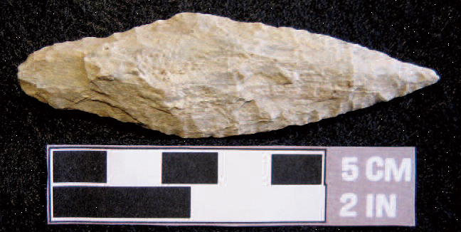
Chert bifaced knife recovered from the upper Tantramar. Although suitable for multiple uses, the thin and serrated blade could have been used to process fish (Colin MacKinnon photo).
In Search of the Fish Weir Lot
By Colin M. MacKinnon
Some time ago, while researching an unrelated topic, I inadvertently stumbled on a local place-name that was unknown to me. This happened while I was going over some old deeds and one of the documents mentioned a place on the Tantramar called the “Fish Weir Lot”. To aid in fleshing out the location of this parcel and to provide a historical context to this fish weir within the changing landscape of the Tantramar Marsh, I present below a number of interconnected topics.
The “Fish Weir Lot” was first encountered in a land transfer from Reuben Wheaton to Thomas S. Wheaton signed on 16 July, 1890. The parcel was described as follows: “all that certain piece or parcel of marsh land situated in Sackville aforesaid and known as the Fish Weir Lot so called and bounded as follows, Easterly by lands belonging to the estate of the late George Anderson, Southerly by the Dixon Ditch, so called, westerly by lands of Jesse Ayer and northerly by Commons Ditch, so called, and containing by estimation fourteen acres more or less” (Land Registry Office, Book U5, No. 58359, Registered 17 July 1891)
Presumably there was a fish weir on this parcel. It would have consisted of a series of vertical wood pickets, intertwined with brush or netting (as there are not many stones on the marsh) that were imbedded into the sides and bottom of a creek. Often the best place for such a weir would have been at the head of tide or at a natural restriction in the river. The weir would direct the intended fish into an area where they would be concentrated and thus easier to catch. The fishermen could have used seine or gill nets but dip nets, still used on the Tantramar today, were more likely if the targeted species was Gaspereau. This parcel has been frustratingly hard to pinpoint and although I had heard about the other features mentioned on the Wheaton deed such as the “Dixon Ditch” and “Commons Ditch”, I was uncertain as to their exact locations. Furthermore, the dyking and draining of the marshlands over the past few hundred years and the in-filling of many lakes has dramatically changed the landscape of the Tantramar, far more than many people realize.

Figure 1. Potion of the Grant map of 1791 showing the many parcels of land on the upper Tantramar Marsh between the Great Bridge and Sunken Island. Salient features: “High Marsh Road” [Solid dark line] and adjacent 4-acre lots, A. Outlet to “Rush Lake” entering “Dead Creek”, B., The 14-acre lot situated on a creek, C. “Fish Weir Road” and “Dixon Ditch” and D. “Commons Ditch” (Top of map is oriented north). (1791 Sackville township map, Mount Allison University Archives, donated by Richard “Dick” MacLeod)
Situated perpendicular to the High Marsh Road from Tolar’s Canal to the Great Bridge (Wheaton covered bridge), were a series of long and narrow, four-acre lots (see Figure 1), these parcels being within the best marshlands for agriculture. Between these small lots and the “floating morass” (bogs and lakes) to the north, were two tiers of these larger lots that were of less value. Although these are labeled on the map as “Twenty one acre Marsh lots”, the actual size appears to vary; again, this may have been an attempt to equalize the value of adjacent parcels. On Figure 1, I have noted the locations of the “Commons Ditch” and “Dixon Ditch” as well as the outlet to “Rush Lake” and the only 14-acre lot (actually 13.9 acres) that was situated between these two ditches as described in the deed. The map depicts a portion of a creek running through this specific parcel. Could this be the “Fish Weir Lot” mentioned in the Thomas S. Wheaton purchase of 1891?
Frequent travelers of the High Marsh Road may be confused by my reference to “Rush Lake” as no such body of water by that name exists there today. Likewise, other water basins such as the original “Goose Lake” (not the one on the road to Midgic) and “Long Lake” (not the one in Jolicure), all situated within the Tantramar Marsh, have vanished.
These were filled in by the technique called tiding, or warping, which turned wetlands into arable land. At this point it is worth taking a short diversion to explain how this technique works. Simplistically, strategically designed and positioned channels are dug such that during high tides, the silt-laden waters of the bay are allowed to flow into low-lying areas and lake basins. Once the velocity of the water has slowed, the load of suspended sediments precipitates out. Over a series of very high tides, a shallow lake could be, in this manner, completely filled in. Before the creation of larger aboiteaus and tidal gates at the mouth of the rivers serving to impede tidal flow, this tiding process was used to rejuvenate fields on the dykelands. Tolar Thompson (c.1780-1846) is largely credited for refining and applying this tiding technology in the Sackville area although the idea was published in the Farmer’s Calendar in 1804 under the title “Warping” (Arthur Young Esq., Secretary to the Board of Agriculture, London, pages 389-395) and dates back to c.1730 in Rawcliffe, Yorkshire (and possibly earlier). The canal that bears his name can be located by travelling about 2.7 km east of the covered bridge on the High Marsh Road. This large ditch is reached just prior to passing the barn owned by the Tantramar Heritage Trust. Once you get to the culvert that crosses Tolar’s Canal at a slight rise in the road bed, the centre of the remnants of “Rush Lake” is situated about 1 km along this ditch, north of the road.
Details in the wording on early marsh maps often provide hints at where tiding took place. While some channels are described as drainage ditches or vent ditches, others are labeled as “tide feeder streams”. It is these “tide feeders” (such as Tolar’s Canal) that were purposely built to bring the silt-laden waters of the bay inland. However, many of these structures, such as Tolar’s, served a dual purpose and also facilitated drainage of the surrounding agricultural lands.
Although the details on the in-filling of “Rush Lake” are brief, the following short accounts, written around 1902 by Winifred E. Thompson (who was likely a relation to Tolar Thompson), provides us a glimpse into Tolar’s work at Rush lake as well as nearby “Goose Lake”; I assume that these descriptions were written by Winifred E. (Thompson) McLellan (1882-1919), the wife of J. A. MacLellan. Her account reads as follows:
“The first great canal he [Tolar Thompson] projected was the Tolar Canal, which ran from the Tantramar River to Rush Lake, a distance of two miles, and drained the commons and the lakes and bogs to the north and east. This was commenced in 1815 and by it about 900 acres of bog and lake were made marsh, and hundreds of acres on either side of the canal were drained and made valuable. The next great work Tolar Thompson undertook was the Goose Lake Canal. No sooner was this work done than the tide rushed in and began to rapidly fill up the lake and must have reclaimed 1,000 acres of lake and bog and greatly improved hundreds of acres of marsh adjoining this canal.” (Winnie E. Thompson, circa 1902 in Chignecto Post, 13 February, 1933).
Winifred provides additional observations in greater detail, probably from family tradition, on the draining and tiding that occurred on “Long Lake” on the main Tantramar River (see Figures 2 and 3)

Figure 2. Map of “Long Lake” completed by the Commissioner of Sewers (Albert Cahill and W.B. Fawcett) in 1895. A copy of that map, shown here, was prepared by R. A. MacNaughton, 14 April, 1928. Note that the “CANAL” is now part of the upper Tantramar River and the old “Long Lake” is now called the “Long Lake Marsh”.

Figure 3. Aerial photograph showing the approximate outline of the original “Long Lake”, on the Tantramar River. This area is now a hay field.
As the process and ultimate landscape changes at “Long Lake” would be similar to the environs following the loss of Rush Lake, it is worth noting in more detail:
“When Tolar Thompson contemplated and succeeded in digging his canal into Long Lake and a branch to Log and other Lakes he did so against the most bitter opposition. He was most firm that by draining these lakes and carrying in the tides of the Bay of Fundy they would all become marsh.
As evidence whether he was right or not, visit Indian Island and there you will see a barn of 75 or 80 tons capacity belonging to Albert Fawcett (see Figure 4). This island is situated about the centre of Long Lake some ten miles up the Tantramar River. Although still called Long Lake it is no longer the large body of deep blue water that it once was but a beautiful meadow of waving grass producing from three to four hundred tons of hay. So deep was this lake, the old men who rafted timber over it say that their 24 feet pole would not reach bottom in many places. In the days of the first settlers of Cookville this and other lakes formed the only highway from Cookville to Sackville, and many were the adventures of the old settlers as they paddled their canoes across these lakes to get the necessaries of life. On one occasion the late John Lund while thus engaged was overtaken by a great gale on Long Lake, his canoe upset, his supplies lost and he only saved his life by swimming to the island and remaining there until found” (Winnie E. Thompson, circa 1902 in Chignecto Post, 13 Feb., 1933).

Figure 4. Long Lake Marsh bridge over the upper Tantramar River and, in the background, presumably the same barn of 75 or 80 tons capacity (inset) which was situated on “Indian Island” and was once surrounded by “Long Lake”. This island was a place of refuge for the nearly drowned John Lund while on a canoe trip to Cookville.
As you can see from the above observations with the ditching and draining of the dykelands and loss of many bogs, lakes and fens on the Tantramar through tiding, tracing exact locations of long forgotten places (not to mention place names) can be problematic. Thus, my first clue to the location of the “Fish Weir Lot” was somewhat contradicted by the second and considerably earlier reference I encountered. In 1789, Nehemiah Ward sold marsh land (on oath of Phineas Ward) to William Easterbrooks for 8£. The transfer was described as follows: “One Lot of marsh bordering Northerly on the Fishwear Pond (sic) and Southerly on the road at the head of the four acre Lots and drafted with number fifteen and likewise all that part of lots No. 15 and 21 that lays on the North side of the Pond or Rush hole. All the aforementioned parcels of land laying on the north side of the main road that leads through the Great Marsh.” Signed 5 February 1789 by Nehemiah and Susannah Ward and witnessed by Phineas Ward and Nathaniel Phinney (1798, Book B1, No. 877, page 254, Registered 27 March 1799).
This deed is interesting in that prior to 1800, there was a commonly known place called the “Fish Weir Pond” and this was presumably adjacent to, or even considered part of, a wetland called “Rush Hole”. I believe this is an early reference for what was collectively, and later, called “Rush Lake”. Jumping ahead to 1966, when the Government of New Brunswick was securing land for the Community Pasture, situated immediately north of the High Marsh Road, there were a number of land transactions. One of these government acquisitions was from Eleanor Brooks of Middle Sackville, Parcel No. 2, and was described as follows: “Bounded on South west in part by the Fishwear Road so called and in part by lands of Vendor, formerly known as A. B. Copp estate; On the North east by Commons Ditch so called; on the south east by lands of David Oulton formerly Vernon Copp. Containing by estimation 21 acres more or less”. (Westmorland County, Deed Registry No. 272354, Page 762, 4 May 1966).

Figure 5. Salient features and remnant tidal creeks (white lines) within the dykelands west of “Rush Lake” and immediately north of the High Marsh Road (Features annotated on a 1953 aerial photograph).
With this third document, I have now confirmed the existence of a “Fish Weir Road”, “Fish Weir Pond” and a “Fish Weir Lot”. Clearly there was once an important fishing site that was accessed by the “Fish Weir Road”. This fishing location (or locations) was (were) also somehow associated with “Rush Lake” (Fish Weir Pond). In Figure 5, I attempt to delineate these places, along with other salient features, that are mentioned in the various parcel descriptions. Although some of the detail is speculative, many of the old tidal creeks that once connected the main Tantramar River with inland lakes, such as “Rush Lake”, can still be traced on the landscape using early aerial photographs (Figure 5). Surviving lakes, such as the three Jolicure Lakes (Large/Big, Long and Front) support a diversity of fish species. Frequently-encountered fish are freshwater species such as Brook trout, White Perch, Yellow Perch and Brown Bullhead as well as the catadromous American Eel and anadromous Gaspereau (also known as Alewife). It is probably the harvesting of Gaspereau that was most likely associated with activities at the fish weir.
Spring fishing for Gaspereau from the Tantramar and Aulac Rivers, although still practiced today, was once far more commonplace. As an example, a farming family’s typical fishing diversion for Gaspereau is wonderfully preserved in the diary of Edward Anderson of Coles Island in 1875:
Wed., 12 May – Forenoon making scoop net, got it done at noon. Bliss got 32 fish. Albert ploughing for Ed Kinear.
Thurs., 13 May – Sharp claps of thunder this morning. George Beal had horse killed by the lightning. Boys got 170 fish at Etter Abito [Aboiteau].
Frid., 14 May – Ploughing and sowing some. Milton and Bliss scoop fishing, got 165.
Mon., 17 May – Boys fishing in the morning.
(In: Marshlands: Records of Life on the Tantramar. https://www.mta.ca/marshland/.)

Figure 6. A classic Gaspereau “smokehouse” that was once used by William “Bill” Landry of Upper Sackville. Sadly, this iconic, and increasingly rare, structure was recently torn down.
Not too many years ago, one would frequently see small and vaguely outhouse-shaped buildings with slanted sides, leaking smoke. And if you did not see the building, your nose would quickly alert you that someone was “smoking Gaspereau”. I suspect that, years ago, there was hardly a self sufficient farm that did not have its own smoke house. However, a driving survey one Sunday afternoon revealed only a few of these mundane but iconic structures remaining in the Sackville area. The best surviving example that Nancy and I could find (that has recently been torn down) was situated on Church Street near the turn to the High Marsh Road that was once owned by William “Bill” Landry (Figure 6). Bill frequently fished and smoked Gaspereau with his friend Earl “Lovett” Carter (b. 1911) of Point de Bute. On more than one occasion, they were accompanied by “Montana Slim”, Wilfred “Wilf” Carter (1904 1996) when he was home visiting family. Wilf (born in Port Hilford, NS, with relatives in Pointe de Bute, NB) was a country singer and songwriter who was often called the father of Canadian country music.
This wonderful little building was a prime example of “form follows function”. The builder was less concerned with exact measurements than following a proven design that ensured properly smoked fish. Construction of the smoke house was both basic as well as creative. As noted above, there was less regard by the builder for exacting measurements and having perfectly square corners than as to have a structure that performed its intended function. The internal framing consisted of four vertical poles, one at each corner, roughly tapering from about 5 to 4 inches in diameter, from bottom to top respectively. The poles were connected horizontally by a series of standard 2″ x 4″ framing with the vertical planking (1″ thick boards were used) attached to these. The entire exterior was then covered with wooden shingles. The construction was presumably by prefabricating the skeleton for two walls (front and back) on the ground, and then standing them up to be joined together at the top. The boards that sheath the smokehouse were scavenged from whatever was available. Some boards were cut with a band saw while others were processed with a circular saw (Figure 7). Furthermore, some of the timbers were rough sawn while others were planed and one charred board was likely saved from a previous smokehouse that had been mostly lost to fire, a common fate to many of these buildings.
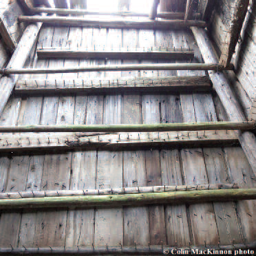
Figure 7. Interior view of the Landry smokehouse. Note the many rows of nails, as well as suspended poles, where the fish would have been hung.
For hanging the fish, nails were spaced about every two inches along the horizontal boards that lined the interior. There were enough nails on just the back wall to accommodate the hanging of 150 fish. A possible later addition was the placement of an internal skeleton of smaller poles, maybe 2″ in diameter, to support a larger number of fish for drying. The small door (20″ by 54″) was barely large enough to step through and was secured by two small steel hinges and a padlock hasp. For those of you who would like to build your own smoker, the base was 8 x 8 feet square. All sides taper to a slanted roof that was about 4 feet square such that the front wall measures 10′ 4″ while the rear wall was 8′ 8″ high. The front side was about 15 inches higher than the rear. The door frame was 2′ 6″ wide by 5 feet high while the actual door measured closer to 1′ 10″ by 4′ 6″.
Pan-fried and smoked, Gaspereau may be an acquired taste to some. However, many of us still appreciate a feed or two every year. It is important to practice some careful observations when consuming Gaspereau as they are a notoriously bony fish. Whereas fried trout can be de-boned in one simple process, the consumption of Alewife needs to be done methodically otherwise one must contend with a number of tiny bones in each mouthful; definitely not a fish to eat when in a hurry.

Figure 8. The “Fish Weir Road” as seen looking east from teh Goose Lake Road; what a story it could tell! The “Fish Weir Pond” (Rush Lake) as situated over 2 km, heading east, down this road.
So what of the “Fish Weir Lot”? My own deductions, followed by talks with Robert Estabrooks and Danny Doncaster confirmed the location of the “Fish Weir Road” (Figure 8). This road departs from the Goose Lake Road and is situated about 1 km north of, and parallel to, the High Marsh Road (Figures 1 and 5). It is interesting to note that the western continuation of the “Fish Weir Road” crosses not only the Goose Lake Stream but also what was once the old channel of the Tantramar River. This same road reaches the uplands of the Brooks family farm where, in 1998, I found in the vicinity evidence of what was an early aboriginal camping area and possibly a fish processing station (see page 1). Interestingly, the old “Fish Weir Pond”, mentioned in 1789, is presumably part of what was later called “Rush Lake” and is also at the “Fish Weir Road”. However, at this point, I still have not been able to conclusively identify the location of the “Fish Weir Lot”. It may be the 14-acre parcel marked “B” on Figure 1 and bordering on the north side of the “Fish Weir Road”. Or the weir may also have been located closer to the junction of where the outlet for “Rush Lake” meets “Dead Creek”. This creek once partly encircled Paunchy Lake and drained parts of the Jolicure Lakes and thus would have been a prime location for catching the Gaspereau moving into these inland lakes to spawn [As an aside, according to Lorna (Bellamy) Etter, “Paunchy Lake” gained its name from waterfowl hunters and trappers who noted the similarity with the spongy feeling of a paunch (stomach) of a moose, or cow, and the texture of the floating moss that surrounded the lake].
The fish weir would have been accessed from the “Fish Weir Road” (Figure 5). Also, as the “Fish Weir Pond” was a name in common use by 1789 it must have been in existence for some time prior to this date. It is very likely that this prime fishing location, situated at the head of tide and connecting to a number of inland lakes, was also known to the earlier Acadian settlers as well as the region’s earliest inhabitants: the Mi’kmaq of the Tantramar. It is interesting to imagine that the wooden remains of the fish weir are probably still entombed within the silt-filled creek bed on the marsh and laying there now, waiting to be discovered.
I would be most appreciative for any new information or family traditions regarding the “Fish Weir Lot” or any details on other poorly known placenames within the Tantramar.
Acknowledgements
A special thanks to the following people who answered questions and shared their knowledge of old place names on the Tantramar: George Coombs (1955-2016), Danny Doncaster, Robert Estabrooks, Lorna (Bellamy) Etter (1925-2017), Mike Green, Jeremy Landry and Helen (Read) Locke.
ANNOUNCEMENT – FUNDRAISING SUPPER
A Taste of History
Friday, November 17, 2017 6 pm
St. Ann’s Church Hall, Westcock NB
Celebrating Sackville’s “Mr. Canadas”: Alex Colville, John Fisher and George Stanley
Catering by Lauri Ann Wesselby, (Sandpiper Catering)
(Menu: creamy autumn soup, tea buiscuits, maple bbq chicken, rice pilaf,
fresh green beans and carrots, apple cheesecake, tea and coffee)
Cash Bar on site
and also
Canadian Classics Singalong
Trivia
Tickets: $50 each (includes $25 tax receipt)
Contact Karen at tantramarheritage@gmail.com or call (506) 536-2541


