december 2018
Editorial
Over the years, numerous friends and members of the Trust have been generous with donations of artifacts that they considered significant to Tantramar history. In this issue, read about a chance discovery in the nearby state of Maine which resulted in a significant donation to the Boultenhouse Heritage Centre. Al Smith relates to us the homecoming of a Boultenhouse sampler returned to its rightful home about 150 years after its creation. As you will likely agree, we all owe a great debt of gratitude to Ken and Anita Upton! This is followed by a fascinating article researched and penned by Colin MacKinnon and of particular interest to me. In the fall of 1972, I took a course at Mount Allison University entitled “Land Use Ecology,” taught by Dr. H. Harries of the Biology Department. In late September/early October of that year, Dr. Harries led us on a field trip to the High Marsh Road, where he discussed the transformation of this ancient intertidal marsh habitat into modern agricultural land, primarily for the production of hay. Prior to hearing Dr. Harries’ explanation, I recall being somewhat confused as to why the dirt road passing through an extensive collection of pastures and hay fields was called the “High Marsh” Road. Where was the marsh? We all stood on the road near the intersection to Midgic where Dr. Harries pointed to old dykes which no longer functioned as such but were later replaced by much larger, newer dyke structures along the Tantramar River. Clearly, the early dykes were constructed to prevent the intrusion of brackish/salt water that flowed into the Tantramar River from the great tides of the Bay of Fundy. Before dyke construction, this land would have consisted of expanses of salt/brackish marsh along the river edges and accompanying tidal creeks. It was a landscape that I had difficulty visualizing as Dr. Harries described the natural habitat that once was. As I listened, a singular question remained with me: why was it important to direct so much time, effort and energy to “reclaim” this land from the Fundy tides in order to produce hay? If we recall our history in the 18th and 19th centuries, horses were the major means of transport and of primary importance to accomplish the necessary farm work in order for a family to survive and, similarly, cattle provided milk and meat. And, in those years (as now!), horses and cattle required hay for energy, especially through the winter months. As you keep these issues in mind, read below the fascinating research accomplished by Colin MacKinnon on “dykeland agriculture” in the late 18th century toward the production of Tantramar hay and the associated technology created to allow for its transportation, storage and export. You will see how hay in those days was of considerable value and will come to view the trading and selling of hay at that time as almost analogous to today’s dealings in energy stocks! Technology was as relevant then as it is today. Hay was certainly a valuable commodity and would have contributed significantly to the economy and growth of the Sackville township. Read on and the next time you drive across the High Marsh Road, think of the value of technological advancements such as Hay Screws and consider those farmers who created the new natural landscape we fondly know as The Tantramar. That drive across the High Marsh Road may never be the same.—Peter Hicklin
Boultenhouse Sampler Returns “Home”
By Al Smith
Since opening the Boultenhouse Heritage Centre in September 2006, the Tantramar Heritage Trust has received hundreds of donations of historical items related to the history of the Tantramar Region. However, very few of those many significant items can be directly traced to the Boultenhouse family. Therefore it was with great excitement when Anita Upton of Manchester, New Hampshire, contacted the Trust office on July 10, 2018, advising us that she had two items made by a Boultenhouse family member and that she and her husband Ken wished to donate them to the Heritage Centre. Anita forwarded photos of a beautiful sampler as well as a crocheted child’s bonnet made by eleven year old Marrimettee Boultenhouse in 1833. The sampler was especially precious as it contained a genealogical listing of her direct Boultenhouse family along with the more traditional elements of samplers from that time.

Ken and Anita Upton at the Boultenhouse Heritage Centre with the 1833 Marrimettee Boultenhouse sampler, August 15, 2018. – Al Smith photo
Marrimettee Boultenhouse was born in Westcock, New Brunswick, in 1822. She was the third child of John Boultenhouse (1795-1873) and Ann Evans (1794-1868) and the niece of Christopher Boultenhouse. Marrimettee (also referred to as Mary) was never married and lived with her parents. She died on July 19, 1875 at the age of 56 years and is buried in the Westcock Cemetery along with her parents and other members of her family. Her younger brother John Edmond was featured in the article Mrs. Boultenhouse Down a Well in Issue #81 of The White Fence.
True to their word, the Uptons traveled up from New Hampshire and met with an excited group of Trust Board Members on the morning of August 15, 2018, and donated the two items into the collections of the Boultenhouse Heritage Centre. Interestingly, Ken and Anita Upton are not related to the Boultenhouse family (as far as we have been able to determine). Anita discovered the sampler neatly folded under a bottom slat of an old seaman’s trunk in her husband’s family home in Maine over 40 years ago. She had the sampler cleaned and framed and it has hung in their home ever since with no knowledge of who this person with the strange name of Marrimittee Boultenhouse was. Her daughter discovered the Boultenhouse Heritage Centre while searching the internet and thus the contact with the Trust was made.


Marrimettee’s unique and original sampler now proudly hangs in the Wry Room of the Heritage Centre along with the 1831 Martha Barnes sampler and a third one from the Wry collection. All are wonderful examples of how young women of the time practiced their skills in fancy needlework. It is also most likely that Martha Barnes and Marrimettee would have known each other in the small communities of Westcock and Wood Point and now their labours of yesteryear are forever preserved and presented to the public who visit the Boultenhouse House Museum.
How this sampler, so painstakingly made by young Marimettee, ended up in Maine we can only speculate. Her older brother Bedford Boultenhouse (1816-1870) was a shipbuilder at his father’s shipyard at Westcock in the 1840s and then became a Master Mariner and moved to Portland, Maine, with his wife Cynthia Barnes (1810-1905). Possibly it was a little treasure from home that Bedford took with him and the seaman’s trunk that Anita found in the old Upton home might have been his. This is pure speculation, but possible!
The Trust is most appreciative of the very significant donation by the Uptons and as Anita Upton aptly commented “How many of these little lady’s samplers now actually hang in the home of their relatives? I would guess not too many.”
Haying, Hay Screws and
Late 18th Century Dykeland Agriculture
on the Tantramar Marsh, New Brunswick
By Colin M. MacKinnon

Figure 1. Load of loose hay being taken across the old covered bridge on the Tantramar River, Bridge Street, Sackville, NEw Brunswick in the early 1900s. (Courtesy Carmel (Wry) Miller, author’s collection)
The harvesting of hay on the Tantramar Marsh, although now heavily mechanized, has always been a time-consuming and laborious process (Figure 1). Dykes and aboiteaux had to be built and maintained, drainage ditches dug, cross drains (or laterals) cleared, and all done with the diminutive dyking spade. Hay, either so-called “English hay” (generally Timothy, Red Top and Red Clover), or “Broadleaf” (Spartina pectinata) was harvested, dried, transported and stored and all the work being done mostly by hand. In the “hay days of the Tantramar” (not heyday as used in the usual definition), a virtual small army of people must have spent weeks on the marsh and an old Tantramar refrain “gone haying on the big marsh”, when asking about someone’s whereabouts, would more often than not have been an accurate response.
We still have a rather poor understanding of dykleland farming during the time immediately following settlement by New England planters and the Yorkshire and United Empire Loyalists that followed in the last decades of the 18th century. Considering the paucity of surviving agricultural records from the Tantramar before 1800 and, as an attempt to extract some details of dykeland activities from a largely untapped resource, I have reviewed nearly two thousand deeds, memorials and Wills in Letter Books A (372 pages), B (364 pages) and C (519 pages), registered between 1785 and 1800, in the Westmorland County land records. Within these documents, containing sometimes near-illegible script, I have focused on the occurrence of the terms “Hay Screws”, “Hay Screws Landing” and “Hay Screws aboiteau” (see Appendix I). This wording only occurs as part of the description of parcels situated within the tier of sixty five, four acre marsh lots, Division Letter A, located south of and parallel to the High Marsh Road, east of the Tantramar River (Figures 2 and 3). Also associated with the “Hay Screws” are other features of interest called “Ward’s aboiteau”, “Broken Bridge”, “Dead Creek” and “Schurman’s Pond” (Figure 4). Of particular note, “Hay Screws” are first mentioned in a sale of 4 acres of land from William Olney to William Cornforth for £4 on 23 July 1776 (although the deed was not registered until 26 September, 1785). Known as lot No.7, this parcel is referred to as being “situate on the Great Marsh to the westward of the Boito [Aboiteau] by which the Hay Screws now Stands.” I think the importance of this document is that it says “by which the Hay Screws now Stands”, implying that this structure, or structures, is (are) relatively new. The wording “Hay Screws” (or just “screws”) was found in 11 deeds from 1776 to 1806 (see Appendix I for details). But, what are “Hay Screws”?

Figure 2. The “Great Marsh,” south of the High Marsh Road and on the east side of the Tantramar River, Sackville, New Brunswick. The “old Coles Island Road” is marked by a dashed line, ending at “Ward’s Aboiteau” (WA). Note the tier of 65, “Four acre Marsh Lots, Division, Letter A.” (Portion of the 1791 Sackville township map drawn by Stephen Millidge, Mount Allison University Archives, donated by Richard “Dick” McLeod)

Figure 3. The approximate location of the various grant divisions as depicted on the 1791 grant map for the Sackville Township as overlaid on a 2001 aerial photograph. This area is within the main body of the Tantramar Marsh, Sackville, New Brunswick (see Figure 2). The area of four acre lots, immediately north and south of the High Marsh Road (H.M.R.) contained some of the higher quality and most valuable agricultural lands within this area. (Aerial photograph DNRE01512 385 07/29/2001)

Figure 4. Detail of the tier of “Four Acre Marsh Lots Division Letter A,” situated south of the High Marsh Road and immediately east of the Tantramar River, site of the “Hay Screws.” Note that Lot No. 32, to Caleb Schurman, is presumably the location of Schurman’s Pond (SP). Ward’s aboiteau was located at number 20 above. See text and Appendix I for details of numbered lots identified above.
In the never-ending quest for improvements and mechanization in agriculture, hay that was compacted (pressed) could be more easily transported, took up less storage space, and maintained its quality following transportation to market. The screw press is an ancient device, a coarse cut thread on a wooden pillar which, when turned like a bolt through a nut, was used for pressing a wide variety of produce such as apples and grapes to make juice. The same technology, with modifications, was also used to press hay and early references tend to use the plural wording of “Hay Screws” to describe the device. Horse power was used to turn the screw to press the hay. Loose hay would have been forked into an enclosed box situated beneath the screw. Horses, as many as four in some examples, were harnessed to arms leading to the screw and, by walking in a circular direction, this arrangement could raise or lower the press device. A screw press, made in 1857 by George Penman, an early pioneer in the Mohawk Valley, is on display in the heritage barn at the South Yuba River State Park, Penn Valley, California (Figure 5). Presumably the press that was once situated on the Tantramar resembled this type of device.
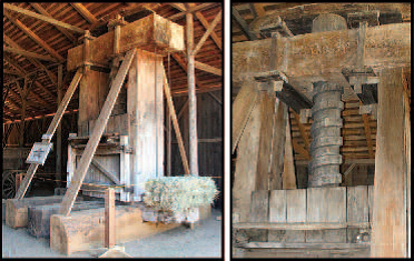
Figure 5. A Screw Press on display in the heritage barn at the South Yuba River State Park, Penn Valley, California. It was made in 1857 by George Penman, an early pioneer in the Mohawk Valley. (Photograph by Herb Lindberg)
Early references for hay screws are relatively rare. Historian Regina Marchi reported that in 1760 an East Boston (Noddle’s Island) resident, Henry Howell Williams, purchased a state-of-the-art screw press for baling saltmarsh hay. She further notes that this “was the only such use of this technology in America at the time” (Marchi, 2015, p. 107). This may or may not have been the very first of such device in the region as we also find in an account on the early history of Boston: “A True Account of the Loss Sustained by Jacob Bucknam in the late Great Fire in Boston in 1760: “210 hundred of Screwed Hay at 22/6 £236” and “1 horse £20 and 1 pair Hay Screws & tackling £45” (in A Volume of Records relating to the early history of Boston containing Miscellaneous Papers, Boston, Municipal Printing Office, 1900, page 61) (Note: 1 hundredweight = 112 pounds). This reference is of particular interest as it mentions the cost of a pair of Hay Screws.
During the American Revolutionary War (1775-1783), cattle (and thus hay), was vital to the war efforts on both sides of the conflict. Graeme Wynn (1979) in his paper on late eighteenth-century agriculture on the Bay of Fundy marshlands, noted, “Market conditions improved in the late 1770s, when British troops in Boston, and later Halifax, raised the demand for all types of fresh produce, and clandestine trade with the American colonists flourished” (Wynn, 1979, page 88). That Nova Scotia, and particularly the rich farmlands bordering the Bay of Fundy, supplied much of these needs, including hay, is well established. Although war also placed New England farmers in a difficult position, Nova Scotia was still seen as the traditional and best source of hay for their livestock. In a letter from Machias, Maine, by patriot Stephen Parker to the Honorable Council of the Colony of Massachusetts Bay (13 May, 1776) we read: “…if I could proceed to the Bay in Nova Scotia & procure a quantity of hay it would be of eminent service to our people, as a large stock of cattle must die if no hay could be obtained but what was cut in the place, we being supplied with hundreds of Tons from Nova Scotia yearly” (Baxter, 1910, page 347).
In Baxter (1910, pages 262-263), there is an interesting account in a letter from William Shirrif, D.Q.M.G. (Deputy Quarter Master General), dated at Boston, 29 May, 1775, and addressed to Thomas Williams Esq., keeper of the King’s ordnance at Annapolis, Nova Scotia (In the following extract from letter, the salient text is in italics): “The Hay will be most Acceptable and I hopes Captain Princes Vessel has taken a part on Board As he promised me he should return immediately, and I will send you another one, as soon as possible. I shall want three or four Thousand Tons of Hay and I wish with all my heart poor Annapolis could furnish it – but all it can furnish I will take, and if they are Industrious they may get a great deal of Money for their Vegetables Poultry Butter Eggs &c…..” and further in letter “I have wrote Messrs Day & Scott at Halifax respecting Forage, and have desired them to Consult with you about the Quantity that may be procured at Annapolis, as they are to furnish the remainder from Windsor, & that Neighbourhood. Procure Hay screws at any rate, and the whole should be carried to a particular place most convenient for that purpose as Also for Shiping of it.” William Shirriff signs the letter and then adds “P/ S If you can possibly add to the Quantity of Old Hay pray do and don’t mind the Expence – W.S” [Note: 4,000 tons of hay at ~ 2-2½ tons/acre would require approximately 1,600 to 2,000 acres of land]. The above request for hay, and need for “Hay Screws” from the Bay of Fundy dykelands in early 1775 is of particular interest as the following account suggests the importance of the Tantramar in supplying this demand for hay and possibly even the above request.
In The Documentary History of the State of Maine (page 315), the following orders were issued to Captain Isaac Danks in October of 1775. Keep in mind that Isaac Danks (1748-1819; buried in Onondaga Valley Cemetery, New York) was the son of Benoni Danks who lived at Westmorland Point (the family dwelling was close to present-day Fort Beausejour/Fort Cumberland). Isaac’s father, leader of Dank’s Rangers, was to side with the American cause and lost his life in 1776 following the failed raid on Fort Cumberland by supporters of Jonathan Eddy. In 1784, Isaac sold his father’s home lot and other lands to Henry Stultz for £170 (Book A1, Deed No. 196, page 201). The following letter addressed to Captain Danks is clearly in response to the demand for hay by William Sherriff, the Deputy Quarter Master General at Boston, as provided by Halifax merchants Day & Scott. Note the “Bundles of Hay” (presumably pressed hay) specified in the cargo. An extract of the letter follows and salient points are underlined:
“Captain Isaac Danks, you are to proceed Immediately with ye Schooner Falmouth Packet now under your Command, to Boston, taking Care to keep Under the protection of the Man of War, who Convoys you; When at Boston you are to wait on William Sherriff Esq. the Deputy Quarter Master General, Whose Orders you are afterwards Implicitly to follow. Respecting the Cargo, on Board of you, please to Observe the following Instructions — 1stly Eight Bundles of Hay Stowed in the Hold and two Barrels of Potatoes, are to be Delivered to Daniel Chamier Esq Commissary General. 2dly The Fifteen Oxen together with the Remainder of the Hay are to be Delivered to the Order of Major Sherriff. 3dly Two Barrels of Potatoes are to be Delivered to Major Martin of the Royal Artillery. 4thly The Potatoes and Turnips which are lose In the Hold you are to Acquaint Major Sherreff thereof and Deliver them to his Order; provided he wants them, either for him-self, Friends or Hospital; If he Does not want them you must dispose of them, and pay the proceeds Into the Hands of Mr Archibald Cunningham.
I sincerely wish you _ prosperous Voyage and _ your Real friend_ Day & Scott
October 20th 1775 Cumberland”
In confirmation of Isaac’s home port, we note the following reference: the schooner Falmouth Packet of 50 or 60 tons “from Fort Cumberland, in Nova Scotia, Isaac Danks, master, bound for Boston laden with cattle, butter, cheese, roots, etc” was seized by John Bunker of Mount Desert Island, Maine on the 24th November, 1775 (Forces, 1843, page 1255).
The link between the above documents and the “Hay Screws” on the Tantramar is somewhat conjectural. From the references, we see that there was a huge demand for Nova Scotia hay in 1775 and the need for “Hay Screws” to press the product for shipment. The location of where the screws were erected is not specified. Further, as a Tantramar link, Captain Isaac Danks who, as previously noted, hailed from the Chignecto Isthmus, was one of the charters to have this hay delivered to New England. It was also on 23 July, 1776, when William Olney sold 4 acres of land to William Cornforth that was described as “situate on the Great Marsh to the westward of the Boito [Aboiteau] by which the Hay Screws now Stands.” As Hay Screws were a comparatively expensive item, they were thus not likely an abundant mechanism in the late 1700s. I make no assertion that the screws requested to be erected by Shirrif in 1775 are the same as those mentioned in the deed of 1776; the timing and connections may be purely coincidental. However, what is clear is the demand for large quantities of hay would likely have been the impetus for the construction of “Hay Screws” on the “Bend of the River Marsh” at the east side of the Tantramar River, by the summer of 1776.
Loose ends
A few other place-names have been uncovered during this research that have been lost to us and their addition here rounds out our understanding of the landscape in the vicinity of the “Hay Screws” in the late 1700s. About 500 m north of the “Hay Screws” a large, once tidal, creek enters the east side of the Tantramar River. Where the dykes once crossed this creek lies the site of “Ward’s aboiteau” (Figure 2). This aboiteau was presumably named after Nehemiah Ward, an early marsh owner in that area. Furthermore an old trail, beginning just east of the covered bridge, followed a sinuous course parallel to the river until reaching “Ward’s aboiteau”. This is still known locally as the “Old Cole’s Island Road”. The records are not clear, but the site of “Ward’s aboiteau” may have also been close to a feature mentioned in old deeds as the “Broken Bridge”. The road past “Ward’s aboiteau” is now barely discernable and there is an inexplicable break in the depiction of this lane on the 1791 map with only a short series of dots connecting the gap (see Figure 2 and in Figure 4; note the row of dots immediately below the number 20 on this map). I wonder if this break represents the location of the “Broken Bridge”. At one time the road continued southerly until it eventually crossed the “Hay Screw aboiteau” at which point it veered easterly and connected with the modern “Coles Island Road”. At this intersection, the continuation of the “Old Cole’s Island Road” became the “Sunken Island Road”.
Some of the place names encountered in early legal documents describe what once must have been easily recognizable features on the landscape. One of these was “Schurman’s Pond”, likely named after early Tantramar settler Caleb Shurman. This lost wetland was presumably situated in the vicinity of Lot No. 32 within the tier of four-acre lots (Deed, Titus Thornton to John Harris, Book B, Page 154, No. 700; see Appendix I). Of biological interest, Schurman’s pond may suggest the past existence of a brackish or bog pond such as are still frequently found at the head of tide in the upper Bay of Fundy.
Another structure of interest depicted on the 1791 map is the “Cross Dyke” that divides the higher quality dyked lands to the north from the un-dyked salt marsh, or “Out Marsh”, to the south. This dyke extended from the western bulge of Sunken Island, following the northern edge of the Sunken Island ditch, and on crossing the present day “Coles Island Road”, connected with the eastern bank of the Tantramar River (Figure 3). Remnants of this old feature have recently been lost due to agricultural improvements in the area.
The value of agricultural improvements to saltmarshes, through dyking, ditching and draining, is well represented in land transactions of the period (Table 1) and the differences in valuations between salt marsh and dyked-lands was specifically noted by Robinson and Rispin as part of their investigative journey through Nova Scotia in 1774: “They value their marsh land that is diked in, and their best cleared land, at three pounds an acre, and their undiked marshes at one pound [per acre]” (Robinson and Rispin, 1774, page 12). For comparative purposes, they further note that, “a pretty good Cow and Calf is valued at £5.10 or £6” (Robinson and Rispin, 1774, page 24).
Conclusion
Surviving records point to the existence of “Hay Screws” on the Tantramar Marsh in the late 18th century as well as an emphasis on the economic importance of the dykelands throughout this period. Although no specific details of the “screws” survive, we are left with an impression of a substantial mechanical device, possibly associated with a storage facility (barn?) as well as a modest dock, or even a brush-work landing on the river bank, to facilitate loading of bailed hay onto small ships or scows that could be navigated up the circuitous Tantramar River (Figure 6). As erosion continuously alters the route of rivers, it is important to emphasize that the specific site of the “Hay Screws” may now be lost (Figure 7). Remnants of an old aboiteau survives today that could be the original, or later rendition, of the “Hay Screws aboiteau” (see Appendix II for details on this structure). Furthermore, the resurrection of once commonly referenced place-names that surround the “Hay Screws”, (such as “Hay Screws aboiteau”, “Wards aboiteau”, “Broken Bridge”, “Old Coles Island Road” and “Schurman’s Pond”) enhances the richness of our Tantramar landscape.
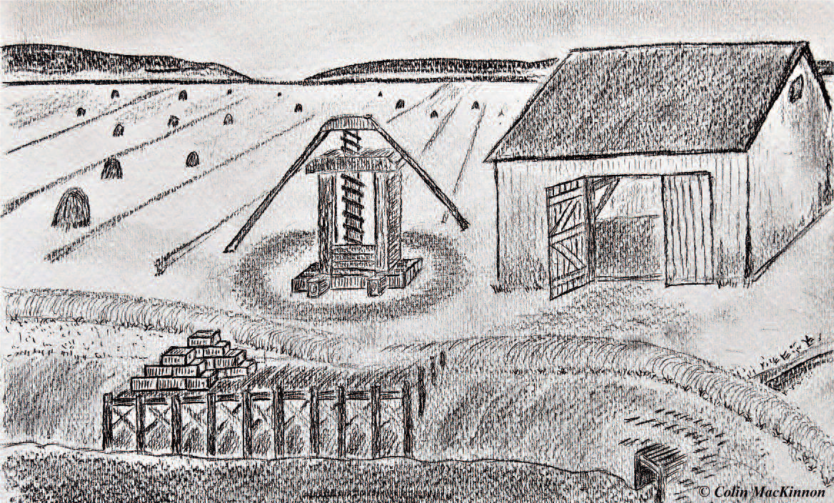
Figure 6. Highly conjectural sketch of the Tantramar “Hay Screws,” “Hay Screws Landing,” and “Hay Screws aboiteau” as they may have looked in the late 1700s on the “Bend of the River Marsh,” Tantramar River, New Brunswick.
Table 1. Comparison of land prices within the tier of Four Acre Marsh Lots, Division Letter A, from 1776 to 1806, Tantramar Marsh, Sackville, New Brunswick.
YEAR Lot No. (acres) Price Price per acre (decimal £)
1776 7 (4 acres) £4 £1
1787 27 (4 acres) £7 £1.75
1789 ½ 21 (2 acres) £1 10 £0.75
1790 10 (4 acres) £5 £1.25
1791 23 (4 acres) £9 £2.25
1791 35 & 36 (8 acres) £14 £1.75
1796 26 & 29 (8 acres)* £25 £3.13
1800 2 & 3 (8 acres) £20 £2.5
1805 22 & 23 (8 acres) £60** £7.5
1806 11 (4 acres) £15 £3.75
* Located by Shurman’s Pond
** The large price of £60 for 8 acres (Lots 22 and 23) may suggest some other improvement to the parcel or missing data in the deed.

Figure 7. General location of where the “Hay Screws” likely stood on the banks of the Tantramar River in the late 1700s.

Remains of an old aboiteau in the area of the “Hay Screws landing” on the “Bend of the River Marsh,” Tantramar River, New Brunswick. Although missing the flapper gate, the wooden aboiteau is still largely intact (sluice interior, inset at right, 18″ x 33″). Note the treenails (wooden pegs – see arrow, inset at left) used in construction of the aboiteau.
Literature Cited
A Volume of Records relating to the early history of Boston containing Miscellaneous Papers, Boston, Municipal Printing Office, 1900, Page 61.
Baxter, James P., Ed. 1910. Documentary History of State of Maine containing the Baxter Manuscripts, Vol. XIX, The Maine Historical Society, Portland Lefavor-Tower Co.
Force, Peter. 1843. American Archives (Fourth series), A Documentary History of the English Colonies in North America from The King’s message to Parliament, of March 7, 1774, to the Declaration of Independence by the United States.
Marchi, Regina. 2015. Legendary Locals of East Boston, Arcadia Publishing, page 107.
Robinson, J., & Rispin, T. 1774. A journey through Nova-Scotia, containing, a particular account of the country and its inhabitants: …By John Robinson, farmer at Bewholm, in Holderness, and Thomas Rispin, farmer at Fangfoss, both in the County of York. York: Printed for the authors, by C. Etherington. South Yuba River Park Adventures, http://www.syrpa.lindberglce.com/barn/haypress.htm (Accessed on 2 February, 2018)
Wynn, Graeme. 1979. Late Eighteenth-Century Agriculture on the Bay of Fundy Marshlands. Acadiensis 8, 2: 80-89.
APPENDIX I
Details of property sales from within the tier of “Four Acre Marsh Lots Division Letter A.” Parcels are listed in chronological order from date of sale (the registry date in some cases may be years later). Individual lot numbers, as shown in Figure 4, are underlined and in bold in the following accounts. Salient notes of land features have been underlined.
William Olney to William Cornforth, Book A1, Page 20, Signed, 23 July 1776 (Registered 26 September 1785), Price £4
“One four Acre lot of land be it more or less No. 7 lying on Sackville first Division Letter A belonging to the right No. 52 and is situate on the Great Marsh to the westward of the Boito by which the Hay Screws now Stands.”
Jonathan Cole (under power of attorney from Benjamin Thurber of Providence, Rhode Island) to Daniel Fletcher (Labourer), Book A1, Page 205, Signed 8 June 1786 (Registered 12 March 1789). Price £34.
Various lots, including: One four acre lot on the Great Marsh, being number one westward of the Old Hay-Screws landing, all belonging to number seventeen aforesaid.”
Joseph Brown to Mark Patton, Book A, Page 118, No. 73. Signed 28 June 1786 (Registered 21 August 1787). Price £10.
Two lots of marsh land containing four acres each and laying on the Great marsh, one lot laying nigh the Screws Aboideau and a crofs Dead Creek the other by the side of the Crofs Dyke, be them more or less, situated laying and being in the Division Letter A. so called in the Township of Sackville aforesaid being the lots known by the numbers Twenty and drawn by me Joseph Brown”
Jonathan Eddy to William Cornforth, Book A, Page 129, No. 96. Signed 26 March 1787 (Registered 24 August 1787). Price £7.
“One Lot of Marsh Land containing by estimation four acres, be it more or less, lying on the Great Marsh near Dead Creek, numbered Twenty Seven, and belonging to the Right or Share number Twenty Eight in Letter A. Division.”
John Barns to William Fawcett, Book A, Page 204, No. 189, Signed 17 February 1789 (Registered 12 March 1789), Price £1. 10. 0.
One half lot of marsh Land containing two Acres and laying on the Great marsh laying near the Screws crossing the dead Creek and bounded Westerly by No. 20. Be it more or less, situated laying and being in the Division of Letter A. so called in the Township of Sackville aforesaid being the one half of the four acre lot known by the name of No. 21 and granted to Andrew Waterman”
Charles Dixon Esq. to Jonathan Burnham Esq., Book B, Page 132, No. 688, Signed 19th August 1790 (Registered 5 April 1796). Price £5.
One four acre lot upon the Great Marsh known by number ten in Letter A Division laying a little to the West of the place known by the Hay Screws.
Hezekiah King to Gideon Smith, Book A, Page 307, No. 347. Signed 2 May 1791 (Registered 10 May 1791). Price £9.
“One four acre lot of land lying on the Great Marsh and belonging to the Right or Share and half number twenty five in Letter A. Division in said Sackville and lying across dead creek drawn by the number twenty three.”
Jonathan Barlow (Yeoman) to Thomas Anderson (Farmer), Book B, Page 121, No. 666, Signed 1st November 1791 (Registered 5 April 1796). Price £14.
Two lots of land containing four acres each more or less, agreeable to the Plan of the Township belonging to number ten in Letter A Division on the Great Marsh now numbered thirty five and thirty six laying both together in the Tier of Lots leading from the Hay Screws.
Titus Thornton to John Harris, Book B, Page 154, No. 700. Signed 11 March 1796 (Registered 5 September 1796). Price £25.
A lot and half of marsh land lying on the Great Marsh and by a Pond known by the name of Shurman’s pond and a half lot laying near the Screws at the South end known by the number twenty six the whole lot known by the number twenty nine the other half lot known by number twenty six the whole lot drawn by William Alverson containing eight acres more or less.”
Thomas and James Easterbrooks to Michael Grace, Book B, Page 174, No. 736, Signed 9 August 1796 (Registered 11 April 1797). Price £21.
“Two half lots of Marsh lands number twelve, one laying between the Screws Aboideau and Ward’s Abyto and the other near cross Dike”. Letter A. Division.
Gideon Smith to John Fawcett, Book B, Page 363, No. 1056. Signed 23rd March 1800 (Registered 20 June 1801). Price £20.
Two four acre lots of land on the Great Marsh numbers two and three in letter A. Division in the bend of the river near the Screws.”
Gideon Smith (Blacksmith) to John Fawcett Jr. and William Fawcett Jr., Book C, Page 200, No. 1375. Signed 5th September 1805 (Registered 27th Jan., 1806). Price £60.
Two four acre lots situate and laying and being on the Great marsh in Sackville aforesaid known by the name of numbers twenty two and twenty three laying together in letter A. Division butting on Tantramar division and laying across the Screws Abt [Aboiteau] creek containing eight acres more or less.” [Note that the high price of £60 for these eight acres parcel may suggest some other improvement on the property or missing data in the deed].
Thomas Anderson Sr. and John Anderson to Jonathan Cole, Book C, Page 212, No. 1393, Signed 3rd Feb. 1806. Price £15.
“One four acre lot of land on the Great Marsh number eleven in the letter A. Division of said Township of Sackville situate in the Screws bend of the river so called, bought by Ira Hicks and Gideon Smith.”
APPENDIX II
Remains of an old aboiteau in the area of the “Hay Screws landing” on the “Bend of the River Marsh”, Tantramar River, New Brunswick.
Remains of an old aboiteau in the area of the “Hay Screws landing” on the “Bend of the River Marsh,” Tantramar River, New Brunswick. Although missing the flapper gate, the wooden aboiteau is still largely intact (sluice interior, inset at right, 18″ x 33″). Note the treenails (wooden pegs – see arrow, inset at left) used in construction of the aboiteau.
Details of aboiteau construction (see photograph above and schematics below). Dimensions are given in inches to reflect the units likely used in the original construction. The tide/flap gate is missing and the entire exposed structure has suffered considerable wear from ice scour. Construction consists of a rectangular box-like pipe. Surviving length of the aboiteau is about 28 feet. Sides are built from two 8″ x 9″ squared timbers that have been stacked one on top of the other and then joined together with 2″ diameter treenails (dowels). This larger dowel (only one example visible) does not appear to project through the top and bottom planking. The top and bottom planking, 2″ x 10½” x 49″, is affixed to the sides by 1″ diameter treenails that are off-set from the centre line of the plank as well as apparently being staggered in their position on each plank (this observation is based on two visible dowels as well as one dowel hole). Note that of the six planks measured, widths varied from 9½” (one), 10″ (two) and 10½” (three). These 1″ diameter dowels extend through the planking and go only about half way through (4″) of one of the 8″ x 9″ side timbers. The bottom of the structure is supported on two large planks (3″ x 10″) that appear to run along both sides of the bottom of the aboiteau. There were no metal fasteners used in the construction. I don’t know the age of this work. As wood survives for a very long time when buried in marsh mud, this remnant likely dates to the mid 1800s and could conceivable be contemporary with the late 18th century Hay Screws.

Schematics for the old aboiteau in the area of the “Hay Screws landing,” “Bend of the River Marsh,” Tantramar River, New Brunswick. See text for details.
Attention!
2019 MEMBERSHIP RENEWALS
It’s that time of year again! Don’t miss an issue of The White Fence by renewing your THT membership. It’s only $30.00 for a family and $20.00 per individual. In addition to the newsletter, you get free admission to the museums, free use of the Alec R. Purdy Research Centre and a vote at our Annual General Meeting (AGM). You can renew online using PayPal, over the phone with a credit card (call Karen at 506-536-2541) or in person at the Boultenhouse Heritage Centre (29B Queens Road, Sackville). Thanks for your support!
OBITUARY Brian Campbell

We were deeply saddened to hear about the recent passing of Brian Campbell. Preserving the Campbell family heritage through the Campbell Carriage Factory Museum is a main focus of the Tantramar Heritage Trust. The reconstruction of the factory compound, and the continuing work to tell the stories of carriage fabrication in the Tantramar region, is a project that was dear to Brian’s heart. We send our sincere condolences to Brian’s family and friends, and especially to Barbara, Erin and Avery.
April 10, 1981–November 15, 2018
It is with profound sadness that we announce the sudden passing of Brian Campbell on Thursday, November 15, 2018 in Calgary, AB. Brian passed away unexpectedly, following a brief illness, at the age of 37. Born in Moncton, N.B. on April 10, 1981, Brian was the son of Barbara (Rees–Potter) Campbell and the late William Ronald Campbell.
Brian attended local schools in Sackville, NB. Upon graduation from Tantramar Regional High School, Brian first attended Bishop’s University and then transferred to Mount Allison University, graduating with a Bachelor of Arts in Political Science and Economics in 2005. After graduating from MtA, Brian headed west to Alberta where he worked for several years in the oil and gas industry. Brian held a number of management positions and worked on many significant pipeline projects at Canadian Natural Resources Ltd., Fluor Corporation and Enbridge Pipelines Inc.
In 2013 Brian returned to the East Coast to attend law school in Fredericton. He was a summer law clerk at Cox & Palmer in Saint John in 2016 and he obtained his MBA and his Law Degree from the University of New Brunswick in 2017. After he graduated from law school, Brian returned to Alberta where he articled with Stikeman Elliott in Calgary. After being admitted to the Alberta Bar in September 2018, he joined Stikeman Elliott as an Associate Lawyer.
In recent years, Brian was involved with the family business, Campbell’s Funeral Home in Sackville. He was extremely proud of his family history in the community and his New Brunswick heritage.
Mild–mannered, even–keeled, kind and funny, Brian had a positive impact on everyone he met. His strength of character, perseverance and quiet intelligence were an inspiration to his family, many friends and colleagues. Brian loved cats, in particular, Rosie and a crazy Bengal named Audrey Catburn. Following in his father’s footsteps, Brian had a passion for old vehicles, including restoring vintage Corvettes.
Brian will be deeply missed by his mother, Barbara (Rees–Potter) Campbell; his sister, Erin Morgan Campbell; his niece, Avery Rees Campbell, all of Sackville; his girlfriend, Caroline McAvity, Saint John, NB; his Aunt, Mary Campbell, Riverview, NB; his Uncle, David (Carolyn) Rees–Potter, Perth, ON; his Godmother, Susan Jenkins (Beverly Smith), Rexton, NB; several cousins and other extended family in the Maritimes, England and Australia, as well as by many great friends across the country.
Brian was predeceased by his father, William Ronald Campbell in 2000, as well as by his maternal and paternal grandparents.
Arrangements were handled by the family business he loved, Campbell’s Funeral Home, 89 Bridge Street, Sackville, N.B. (506) 364–8188. A celebration of Brian’s life was held on Saturday, November 24, 2018 at 2 pm at the Mount Allison University Chapel, 63B York Street, Sackville, when individuals shared memories and words of gratitude for Brian’s life. A reception followed at Tweedie Hall, located in the Wallace McCain Student Centre.
If so desired, donations in memory of Brian may be made to the Campbell Carriage Factory Museum (through the Tantramar Heritage Trust Inc.) or to the charity of one’s choice. Online condolences may be forwarded to the family through the website https://campbellsfuneralhome.com/ or by visiting the funeral home Facebook page @campbellssackville.


