february 2022
Editorial
Dear Friends,
Over the years, my experience as your editor has been one of discovery. This newsletter is no different. I had never heard of there ever having been a rifle range in Sackville. But when asked a question about it, as you will read here, Colin MacKinnon was able to clarify and elucidate. And he does again in this issue. What I found especially interesting about this rifle range was the many land transactions involved with it over time; in this case, a period extending over the years 1909-1954 with Colin’s personal observations in 2021 added in. This exchange of property is a process that is often central to understanding important aspects of the history and social landscape of a city or town. The details of the land under discussion in the text are further described by Colin in the accompanying appendix. Many of you may be very familiar with the Sackville Rifle Range as it was likely used for shooting practice by local hunters in the area over the years of its existence. However, with two World Wars over the past century, the range would have been especially important to the military. But for others like me, it is a new and fascinating discovery. So settle yourself in your favourite chair, read on and …
Enjoy!
—Peter Hicklin
Heritage Day
Join us on Saturday, February 19 at 2 p.m. as we celebrate Heritage Day with a presentation by Paul Bogaard on his new book, The Cumberland Basin Grindstone Industry: A Compendium of Sources and Illustrations. This will be a virtual presentation, so you’ll be able to join us from the comfort of your home. A Zoom link will be emailed to members prior to the event. You can also check our Facebook page (Tantramar Heritage Trust) or contact Karen at the office at (506) 536-2541 or tantramarheritage@gmail.com to receive the link.
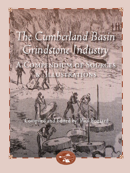
The book will be published in March and copies will be available at the Boultenhouse Heritage Centre and Tidewater Books in Sackville. This will be the Trust’s 38th book on local history.
This event is held in partnership with the Town of Sackville.
History and Archaeological Reconnaissance of the Sackville Rifle Range in Sackville, New Brunswick
by Colin M. MacKinnon

Figure 1. General location of the “Sackville Rifle Range”, Sackville, New Brunswick, as well as the woodlot owned by Hilyard Crossman centered on the “Hicks Place” (Note the approximate location of shooting platforms: A – 600 yds, B – 500 yds and C – 200 yds; mound “C” could not be located in 2021).
David Beattie, a respected military historian and editor of Vincent Goodwin’s WW I diary, once asked me, “Do you know anything about the shooting range past York Street?” Much to his surprise, I was able to describe to him the location of the range (situated immediately west of the intersection of York Street and the Crossman Road) along with some information about the shape and size of the small shooting platforms, or mounds, as well as the condition of the backstop (Figure 1). The information I shared was based largely on site visits years ago with my father as well as from family tradition since some of the range had straddled property owned by my grandfather Hilyard Crossman Sr. (1902-1963). My answer to David also revealed how little I actually knew about the site: who owned the land? When did the range open? How long did it operate? When did it close? As we continued our discussion, my lack of details led to more questions than answers. Thus, the following article provides a more complete account of the history of the “Sackville Rifle Range”; a timeline of the site follows in Appendix 1. Measurements are expressed in Imperial units as used during the operational era of the range.
The Sackville Rifle Range consisted of a 60 ft. wide swath cut through the forest with an outwardly expanding safety zone, allowing for overshoot and ricochet of projectiles, extending on either side of the shoulders of this corridor. As measured from the backstop, this safety zone extended 150 yards from each side of the range proper (Figure 2).

Figure 2. At top, blueprint of the Sackville Rifle Range showing extent of land covered by the range and surrounding “danger area” extending from the end of York Street to the Mill Brook on the Lower Fairfield Road, Sackville, New Brunswick (Plan showing DANGER AREA, DND, 26 February, 1938). At bottom, an enlargement of the range proper showing the Department of National Defence (DND) land at the end of York Street, that was secured as part of the “Sackville Rifle Range”, as well as the 4.9-acre parcel leased from Hilyard Crossman Sr. (Surveyed by Thomas D. Pickard, Provincial Land Surveyor, 26 February 1938; author’s collection).
The site was described as consisting of three lanes, wide enough to accommodate three marksmen with a matching number of targets down-range (Figure 3). The backstop and target area was situated against the slope of a ridge that ran about 50 m from, and parallel to, the west bank of the so-called “Indian Brook”. Part way up this slope, a trench had been dug with the spoil thrown downhill such that an elevated berm was created perpendicular to the axis of the shooting corridor. This berm (measuring 24 feet long and 4 feet high in 2021) would have supported the three targets, while the “ditch” up-slope was once deep enough for someone to point “hits” on a target while still being safely protected in an area called the “target markers gallery”. In the early 1970s, I recall seeing the remains of a small wooden hut at the northern end of this trench (entry was from the south) where I was told by my father that this was where the targets were once stored. The footprint of this little building looked to be no larger than a typical outhouse – maybe 4 x 4 ft. On this visit, only the roof and about the top two feet of a doorway was visible as years of erosion from the slope above had largely in-filled the trench and buried the shack. The steep slope above the berm and trench acted as the backstop for the range. It is here, after a spring thaw, where spent lead bullets could often be found as they became exposed from the rain-washed face of the earthen bank. Not much of this infrastructure is visible today (Figure 4). Inexplicably, a few years ago a forest access road was built directly up the steep slope and through the northern edge of the berm and backstop such that some of the features, as described above, have been lost.

Figure 3. View of the Amherst, Nova Scotia, rifle range with targets in the far distance. The “Sackville Rifle Range” would have looked similar. The marksman lying prone at centre of image, third from left, is RSM George E. Lawrence (photograph courtesy Everett Mosher).

Figure 4. View of the target area and backstop of the Sackville Rifle Range. With a little imagination, one can visualize the approximate location of the target positions 1 to 3 as supported by the berm in front of the backstop. The location of the small target storage building, protected by the berm is indicated by a “T” (4 February 2021).
I had wondered if the range was strictly for military training or if it was used by local hunters looking to improve their shooting skills. Over a number of years, I have collected a few “relics” as they became exposed from the backstop. Most projectiles were heavily deformed from striking small stones in the earth. However, those that survived intact could be easily identified as standard .303 metal jacketed lead bullets (so called Military “ball” ammunition): they consisted of either 215-grain “round nose” or 174-grain “pointed nose” bullets (Figure 5). No non-military ammunition was recovered from the site. Only a very few empty brass casing were found and these were solely from .303 ammunition.

Figure 5. Examples of standard military .303 jacketed lead bullets recovered from the backstop of the Sackville Rifle Range: top row, 215-grain and at bottom 174-grain projectiles. No non-military ammunition was recovered from the site.
A portion of the much larger “danger area” as found on either side of the three firing lanes bisected a small 10-acre parcel of land called the “Hick’s Place” as shown in Figure 2. This cleared knoll, surrounded by forest, was the 19th century homestead of millwright George Hicks (1817-1894) (see White Fence #28, 2006). As an aside, even though the Crossman family has owned the property continuously since 1905, after 117 years it is still known locally as the “Hicks Place”. With regards to this parcel, my mother had always understood that the government had paid her father some sort of an annual allowance for use of the property. In actuality, there was a formal lease for the aforementioned portion of land that fell within the range’s danger area.
On the 22nd June 1939, Hilyard Crossman Sr. signed a “Shooting Rights Agreement” with the Department of National Defence (DND) for the lease of 4.9 acres of the “Hicks Place” lot for $10.00 per year. As the danger area extended not just on both sides of the range but also for an additional 2,400 m down-range of the backstop, a similar agreement would have been required between DND and a number of other landowners.
This agreement contained nearly two pages of conditions, including a clear indemnity to save the Crown “harmless” in the event of an accident. The wording was as follows: “the said Lessor further promises and agrees that if, through, or by any reason of, Rifle practice on the said range, any injury is caused to him, or to any of his employees, servants or agents, or to any of his horses, cattle, sheep and other livestock, or to his crops, the Lessor will not hold His Majesty or any of his officers or servants, or any person or persons duly authorized by His Majesty to carry out rifle practice on the said range, responsible for such injury, and will not look to His Majesty or any of his officers, or servants, or any person or person duly authorized to carry out rife practice as aforesaid, for compensation therefore, and will indemnify and save harmless His Majesty and any of his officers or servants, or any person or persons duly authorized to carry out rifle practice as aforesaid, from and against any claims or demands whatsoever which may be brought against them by reasons of such injury” (Agreement between Hilyard Crossman and His Majesty the King, 22 June 1939). After nearly 22 years, the Crossman lease with DND was terminated on the 23rd February 1951.
I wondered if perhaps, with World War II on the horizon, a heightened patriotic spirit may have been a motivating factor for the various land-owners to allow the Department of National Defence to use their property. Besides grandfather Hilyard, the other property owners were: T. A. Siddall, Mount Allison College, Estate of Willard Bowser, Charles Bembridge, Charles M. Wry, Fred Babcock, William Wheeler, Frank T. Mitton, Ernest Bulmer and the Town of Sackville.
The first formal notice of a range situated past the end of York Street appeared in a sale, 30th June 1909, from Senator Josiah Wood and his wife Laura to James F. Anderson (1880-1960), Charles Pickard and Clinton C. Campbell (1859-1928), trustees of the Sackville Rifle Club (Westmorland County Records No. 91399). James F. Anderson, one of these trustees, was a prominent Tantramar farmer and dykeland manager who was actively involved with the Sackville Rifle Club. From notes written by James’s wife, Annie (Morton) Anderson, we are fortunate to have the following biography that highlights his diverse and exemplary career:
“James Fairweather Anderson attended school at Upper Sackville and Middle Sackville. He was a member of the Middle Sackville United Baptist Church and their choir from 1898 on. When the church was divided in 1903 he was elected a trustee and continued in that office, also a deacon from 1906. He was a commissioner of the West Marsh body from 1916 to 1946, a trustee of the Middle Sackville school district from 1918 to 1939 and a trustee of The Four Corners Burying Ground. He was a member of the Sackville Rifle Association (Civilian) from 1902 to 1914 and from 1925 to 1939, winning a trophy for the highest aggregate score in 1910 (the Major Pickard Trophy; see Figure 6). He was also a member of Sackville Cornet Band from 1904 to 1907, playing the tuba. A liberal in politics, he was appointed to the Provincial and to the Federal Marshland Commissions under the Maritime Marshland Rehabilitation Administration (M.M.R.A.) of the federal government from 1949.” (Transcript courtesy Bertha (Wheaton) Douglas).

Figure 6. Trophy inscribed: “SACKVILLE RIFLE ASSOCIATION, MAJOR PICKARD TROPHY, HIGHEST AGGREGATE SCORE, SEASON 1910” won by J. F. Anderson”. (Courtesy Fred Anderson collection).
James F. Anderson, noted above, also appears as a younger man in a photograph of a group of marksmen, circa 1905 (Figure 7). The shooting range in this image was once situated past the long vanished “Wright’s Farm”, and parallel to the Trueman Mill Pond on the Etter Ridge Road. An anecdote has been told that years after this range closed, there was a lumbering operation in the forest down range of the old backstop. When the woodsmen were felling timber, there would be a shower of sparks whenever the cutting teeth on the chain-saw struck a bullet that had been imbedded in a tree (recalled by Don Colpitts as told by Wayne Siddall).

Figure 7. Group of marksman in front of the backstop of a shooting range that was once situated parallel to the east side of the Trueman Mill Pond on the Etter Ridge, New Brunswick, circa 1905. At right: James Fairweather Anderson (1880-1960), trustee of the “Sackville Rifle Club” and winner of the Major Pickard Trophy in 1910. Tentative identification for some of the other men in the photo: Hazen Etter (young man, 2nd row, 1st on the left); Al Wells (large man, 2nd row, 3rd from left in bowler hat), Bliss Lowerison (far right, 2nd row, wearing a uniform and corded hat with badge). Photograph courtesy Phyllis Stopps.
In 1939, the Sackville Rifle Range property (12.6 acres [5.1 ha]), was acquired by the Department of National Defense (DND) from the Civilian Rifle Association by Order-in-Council, PC #2330, 21 September, 1938. Following that acquisition and during the war years (1939-1945), the range was used by various Canadian Army units such as “C” Squadron, 5th Canadian Armoured Regiment (8th New Brunswick Hussars), and C Company, 2nd Battalion of the New Brunswick Rangers as well as the COTC (Canadian Officers’ Training Corps) of Mount Allison University and staff of Dorchester Penitentiary. The DND estimated that the range was used by 500 personnel annually. In 1944 through to 1946, a number of repairs and improvements were recommended, however, it is unclear if any work was actually done (see Appendix). The main stumbling block was the expenditure of a significant amount of public funds on land that was not entirely owned by the Crown. Finally, in 1954, DND transferred the “Sackville Rifle Range” parcel back to James Anderson who was “the surviving trustee of the Sackville Civilian Rifle Club” (Order-in-Council, PC #1319, 8 September 1954).
I had assumed that any specific details regarding the actual operations of the Sackville Rifle Range would have been long gone. However, thanks to the sleuthing efforts of Bertha (Wheaton) Douglas, the granddaughter of James Fairweather Anderson, we are very fortunate to have the following detailed description of operating procedures at the Sackville Rifle Range as written by her uncle Donald Anderson (1918-1991): “Papa [James Fairweather Anderson] was a marksman. He pursued this interest nearly every Saturday afternoon during the summer when he went to join the rifle shoot on the rifle range in the woods just north of Sackville. There, in a wide track of trees cut down, was a range with two targets at one end and shooting “mounds” at 200 yards, 500 yards and 600 yards along the length. The mounds facilitated marksman-like shooting over the tops of the bushes. The targets were 4-5 foot rectangles of white canvas (or equivalent) mounted on a frame counter weighted and hung from pulleys so they could be raised to open view and lowered behind a thick earthen parapet. When the tenders heard the echoing crack of a rifle, they would look at the target to spot a hole. As soon as the hole was spotted, the target would be drawn down. A circular flat marker 2 or 3 inches in diameter, white on one side and black on the other and with a peg through the center, would be removed from the previously-made hole and plugged into the new one. The white side would be made to show if the hole were in the black target area, and vice versa. The previous hole would then be patched with a quickly-sticking ready-made patch, and the target raised for the next shot. The location of the target area was arranged so that on passing through the target, the bullets ran into a substantial hill of earth behind [see Figure 4].
A set of coloured metal circular signals was hoisted beside each target to signal whether the new hole was a bull’s eye, an inner, magpie, outer or a miss visible on the target after each shot. Charles [Donald’s brother] and I tended target several times and got familiar with the requirements.
Back on the firing mounds, the competing marksmen assembled for the afternoon shoot. The 200-yard mound came first. The 200-yard targets run up on the target hoists behind the parapet were slightly smaller than the 500/600 yard ones. Four marksmen would lie down across the mound with their rifles taking turns shooting at the two targets. The others waiting their turn would mark down the scores on the scorecards and observe the location of the marker. Each marksman with the knowledge of the target distance, the location of his last shot on the target, any crosswind on the range as well as his own impression of his shot, would adjust his sight appropriately for the next shot. Most marksmen will know before the signal comes up approximately where on the target his bullet will have struck and will almost certainly know if he has missed.
The rifles were regular army Lee Enfield .303s. The gun has a wooden protective shield held on around the gun barrel. Marksmen often added their own choice of adjustable “peep-hole” sight for the rear sight. Sometimes they had the rifle “bedded” by a professional. This consists of putting certain linings in between the barrel and the wooden shields to influence the action of the barrel while the bullet is passing through. The barrel actually bends in a certain way during this passage so that a marksman’s accuracy can depend to a large degree on the consistency of this behaviour.
There is also a strap on the rifle that can be arranged around the left arm (for a right handed, “right eyed” person) to help hold the rifle still. One normally stops breathing for the last few moments before squeezing the trigger. However, one cannot stop one’s heart and sometimes the strap is tugged by an artery in the arm. The strap can usually be rearranged to avoid this. However, being excited or nervous driving a shot is no help!
I remember the first one or two times my Dad handed the rifle to me to try a shot on target. I made bull’s eyes and inners on the first few shots. Then excitement began to take its toll. My score slipped down a bit. It took a lot of control to bring my score back up again. Papa was a very good shot and made quite high scores. This is quite in keeping with his laid-back sort of continuous good-humoured approach to everything.
In 1927, I [Donald Anderson] was nine years old. It was a special year. It was the 60th anniversary of Canada’s nationhood. That summer, our aunt Patience and Uncle Alex, who lived in Coronation, Alberta, came to visit us for the summer. Papa was well into the marksmanship thing about then. He took advantage of the presence of Uncle Alex to take a week off, right in the middle of haying season, and go down to Sussex to compete in the annual rifle shoot. This was an event in which marksmen from all over the Maritimes (or was it Canada?) came. Papa left Uncle Alex in charge with the hired man and us kids to do the work. Uncle Alex promised us that if we worked hard and did everything right, he would take the lot of us kids to a trip to the theatre down in Sackville to see a MOVIE; the first one ever for, at least, Charles and me!”
Thanks to this detailed description by Donald Anderson, we have a first-hand account of the actual operations of the facility. Organized training by the military and local rifle club appears to have ended by 1954. Very few traces of the long-abandoned Sackville Rifle Range can be seen today. A popular snowmobile and ski trail now meanders along the length of the old range and the 500-yard shooting mound makes a nice, shaded, rest spot if you know where to find it (Figure 8). The target area and backstop are now barely recognizable as anything of significance.

Figure 8. View of the 500 yd. shooting mound of the old Sackville Rifle Range. The top of the shooting platform measures 10 x 24 ft. (30 January 2021)
The Sackville Rifle Range, now largely lost to memory, was once part of this community’s contribution towards Canada’s war effort during the Second World War. For a more detailed chronological account on the history of the Sackville Rifle Range, see the Appendix below.
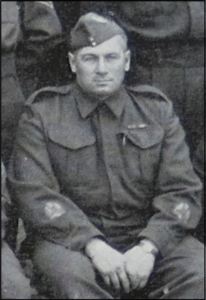
Figure 9. RSM George E. Lawrence, 5th Canadian Armoured Regiment (8th New Brunswick Hussars), 15 May 1941.
This article is dedicated to RSM George E. Lawrence (1898-1980), 5th Canadian Armoured Regiment (8th New Brunswick Hussars) (Figure 9). In 1959, he was part of an 18-person team of marksmen who represented Canada at the National Rifle Association Meet in Bisley, England. His many accomplishments were recognized in 1989 by his induction into Sackville’s Sports Hall of Fame.
Acknowledgements
A special thanks to Bertha (Wheaton) Douglas for sharing her family’s stories, including the rare description of the Sackville Rifle Range in operation and to Fred Anderson for showing me his grandfather’s trophy. A note of appreciation also goes to Don Colpitts, Glen Crossman, Linda Fury, Everett Mosher, Nick Sanders (DND) and Phyllis Stopps who all assisted with this article.
APPENDIX I
Timeline regarding various activities pertaining to the Sackville Rifle Range, Sackville, New Brunswick (sourced from various files from the Department of National Defence).
1909 (30 June) – Senator Josiah Wood and his wife Laura conveyed land to James Anderson (1880 1960), Charles Pickard and Clinton C. Campbell (1859-1928), trustees of the Sackville Rifle Club (Westmorland County Records No. 91399). The reason behind this transaction is explained later in the 1939 land purchase: “Whereas “C” squadron of the 8th Princes Louise Hussars some years ago had taken over the said Sackville Rifle Club the operation and management of the said Rifle Range, and have continued to conduct Rifle practice thereon up to date, but had never received a transfer of title of the Real Estate from the said trustee.”
1912 – The Sackville Rifle Association and several Militia units (8th Hussars and 74th Battalion) acquired the Sackville Rifle range around 1912 under sponsorship of DND.
1912 (November) – “The Plan of the Sackville Rifle Range. The plan shows the position of existing Markers shelter, and 200x, 300x, 500x, and 600x firing points, and the suggested extension to 800 & 900 yards with danger area necessary for a target range.” (The General officer Commanding, 6th Division, Halifax, NS).
1913 (13 November) – “The rifle range at Sackville, N.B. would accommodate: “C” Squdn. 8th Hussars; “E” Coy., 74th Regiment and No. 173. Sackville Rifle Association – Membership 40.” And “If it is possible to secure a rifle range at a reasonable price, which should accommodate the Militia units above mentioned and the Rifle Association, it would appear advisable to do so.” (R. A. Helmer, Lieut. Colonel, Director of Musketry, DND memorandum).
1938 (1 September) – Order-in-Council (PC #2330) approving the leasing of approximately 1 acre of land from “C” squadron, 8th Princes Louise (NB) Hussars.
1938 (9 September) – ““C” Squadron, 8th P. L. (N. B.) Hussars hold title to about 11 acres of land in the vicinity of Sackville, New Brunswick, which they use as part of a rifle range, the targets being on land leased from Mount Allison University, and the danger zone over lands belonging to various parties. The Hussars have offered to convey title to the Crown for the land they hold, provided the Department of National Defence refits the range and undertakes future operation of the same.” And “The proposed range would be used not only by the Militia Units in the vicinity of Sackville, but also by the prison guards at Dorchester Penitentiary about 8 miles distant.” (Minutes of a meeting of the Committee of the Privy Council, 21 Sept., 1938).
1939 (6 March) – Range property was acquired by DND (12.6 acres) from the Civilian Rifle Association (Order-in-Council, PC #2330, 21 September 1938). Shooting rights over the down range “danger area” acquired from landowners.
1939-1945 – During World War II, the rifle range was used by the Canadian Army units including C Squadron, 5th Armoured Regiment (8th Hussars), C Company, 2nd Battalion of the New Brunswick Rangers, the COTC of Mount Allison University and staff of Dorchester Penitentiary. DND estimates that the range was used by 500 personnel annually.
1944 (21 December) – $3,503 was approved for the following proposed improvements: $1,602 for concrete markers, shelters backfill; $1,080 for installation of 3 standard steel target frames, and $480 for clearing approximately 4 acres of land (Total $3,202).
1945 (2 April) – Request for $7,600 for reconstruction of the 3 target rifle range in Sackville, N.B.
1946 – In 1946 the range was identified for post-war use and the infrastructure was improved [Note: it is not clear in the records if any work was actually done].
1946 (19 September) – “The DOC MD 7 states that deterioration of the range is such that its reconstruction is necessary, the estimates cost of this being $5,300.00 and he further recommends that the work be done in or about the month of May 1947.” However, the document further states “I do not recommend the expenditure of this amount on rented property, but recommend that this item be included in the Annual Estimates 1957-1948 with steps being taken this year to purchase the land presently leased.” (DND, Engineer Services, Ottawa). It does not appear that any of this work was done as no lands were acquired.
1950 – Internal memorandum recommending that DND terminate agreements pertaining to DND
shooting rights at the site.
1954 (1 November) – DND transferred the Sackville Rifle Range parcel back to JAMES ANDERSON, the surviving trustee of the Sackville Civilian Rifle Club (Order-in-Council, PC #1319, 8 September 1954).


