february 2021
Editorial
Dear Friends,
Come with us on two exciting journeys! The first is a trip by horse and sleigh in the early part of the twentieth century when horses were still the primary mode of transportation. But this is no ordinary trip; Frank Ward and daughter Teckla travelled by sleigh around the Jolicure Lakes in winter… and then the weather turned. So hang on to your seats as Colin MacKinnon take us on a sleigh ride you won’t soon forget! Then Colin and Irish immigrant Andrew Kinnear turn back the clock of time to carry us into Tantramar in April, 1785. On that date Kinnear, an officer at Fort Cumberland, wrote a report on the state of agriculture, fishing, lumbering and shipping in this area. Read Andrew’s report and walk back in time to experience life in early Tantramar. It is an eye-opener!
Enjoy!
—Peter Hicklin
Lost in a Blizzard
while travelling the “winter road” across Jolicure’s Large Lake

by Colin M. MacKinnon
If anyone has spent time in the vicinity of the Jolicure lakes, situated about 11 km north-east of Sackville, one is struck by the comparative remoteness of the place. Buffered by the Tantramar Marsh to the south, woodlands to the north and the lakes otherwise fringed by floating Black Spruce and sphagnum bogs, it is an area not easily accessible. Now largely protected within the Tintamarre National Wildlife Area, administered by the Canadian Wildlife Service, Environment Canada, this piece of hinterland gives us a glimpse of times past. The observant visitor will notice gnarled apple trees, Cinnamon Rose and Hop vines: the remains of old, long abandoned homesteads scattered along the Lake Road (Figure 1).

Figure 1. Aerial photograph of Jolicure Large Lake showing locations of old homesteads as well as the approximate orientation of the “winter road” across the lake (dashed line). Aerial photography courtesy Andrew Kennedy

Figure 2. The old Bellamy family farm “over the lakes” in Jolicure. Photograph courtesy Linda Fury (Lorna [Bellamy] Etter collection).
Frank Ward (1875-1945) of Wilbur’s Cove, Rockport (Figure 3), married Clarissa Oulton (1888-1933) of Jolicure on the 20th February 1901.

Figure 3. Frank L. Ward (1875-1945) at his farm at Wilbur’s Cove, New Brunswick (c. 1935). Frances Jean (Ward) Keenan collection, see Ward 2009, p. 157.
They began their married life living with Clarissa’s parents, Stewart and Amelia Oulton. By 1911, they had moved and were living on their own farm, back on the Jolicure Lakes, with 5 young children. Also living in the household were Frank’s nephews, Brenton and Frank Read, who likely helped with the farm. Brenton and Frank were the sons of Alpheus and Margaret (Ward) Read of Johnson’s Mills. Sadly, on the 19th September 1901, when Margaret “Maggie” was just 34 years old, she died of tuberculosis and the boys were raised by Frank Ward and his family. Besides maintaining a small farm, Frank also prospered in the lumbering business and was able to build for his family a substantial home (Ward, 2009). Today the house is long gone with only an empty cellar to mark the spot. The surrounding 6 ha (15 acres) of field that once delineated the property is now covered with a tall stand of “pasture” spruce. The following story likely occurred sometime around 1910, or shortly thereafter, when their daughter Teckla (1903-1987) (Figure 4) was a young girl yet old enough to vividly remember the event.

Figure 4. Teckla Ward (1903-1987) and her husband Ernest B. Tower (1902-1990). Photograph courtesy Ken Tower collection.
When living at the Ward farm throughout the winter months, it must have felt even more isolated than at other times of the year. However, when snow and ice conditions allowed, one could leave the roads and travel by sleigh across country to do errands and visit friends. At the sharp bend of the Jolicure Lake Road, adjacent to the site of the old Townsend farm, there is a lane that leads down to the boat landing of Jolicure Large Lake (see Figure 1). This trail is more than it appears as it once was the eastern anchor of a nearly one kilometer long “winter road”, over the ice, to the Brooklyn Road and nearby Midgic to the west. This “winter road” greatly shortened the distance to those neighbouring communities and was an important travel link in the winter months.
On a crisp winter day, Frank Ward hitched the horse to the sleigh and, after bundling young Teckla in the requisite buffalo robe for such trips, headed west across the lake. On their return, the weather had deteriorated and it had started to snow. They had only progressed a short distance over the ice when a raging blizzard, accompanied by a “white out”, blocked their visibility and they were soon lost. As mentioned, Jolicure Large Lake is predominantly surrounded by a series of low-lying bogs save for a low ridge situated just above the landing on the east side of the lake. As such, there are few distinguishing features to aid in navigation as viewed from the middle of the lake (Figure 5).

Figure 5. One out on the water, much of the vegetated shoreline of Jolicure Large Lake is devoid of many identifying features. Photograph courtesy Earl Bowser collection.
Teckla must have been terrified as her father tried to guide the horse through the swirling snow while searching in vain for the landing and safety. If they ventured too far off course, there was a chance of breaking through the ice, either near the inflow at Robinson Brook to the north or around the outflow at Fillmore’s Hole to the south. In the end, the horse saved the day. It was able to find its way unguided through the blizzard until reaching the landing and woodland trail. This event was seared in Teckla’s memory and the story was told and re-told to her family. In 1918, Frank, Clarissa and family moved back to Frank’s parent’s place overlooking Wilbur’s Cove in Rockport. The homestead was secured through the good graces of Frank’s sister Augusta who became an accomplished opera singer. When Frank made the move to the property at Wilbur’s Cove, she said, “You can have it as long as you pay the taxes on it” (Ward, 2009, p.83). One wonders if the event on the ice, that cold and blustery day, had anything to do with Frank and Clarissa’s decision to move to Rockport, although the family recalls that Teckla always loved Jolicure and the lakes!
Acknowledgements
I would like to thank Ken Tower for sharing this story about his grandmother Teckla Ward. I extend a special acknowledgment to Lorna (Bellamy) Etter (1925-2017) and Helen (Read) Locke (1925-2019) for their many stories while reminiscing about their childhood in Jolicure and life at the Bellamy farm, “over the lakes” in Jolicure (note that the Bellamy farm was previously owned by the Acton family).
References
Ward, Jeffrey P. 2009. Head of the Bay, A History of the Maringouin Peninsula. Tantramar Heritage Trust, 240 pages.
Particulars collected at Fort Cumberland and its neighbourhood
A report prepared by Andrew Kinnear, Assistant Commissary, Fort Cumberland, 21 April 1785
Presented by Colin M. MacKinnon
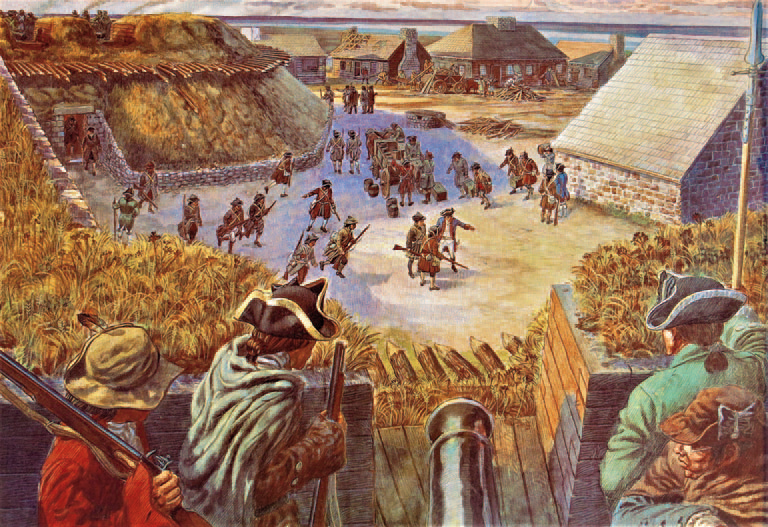
Figure 1. One of the Lewis Parker paintings, displayed on the grounds of Fort Beausejour/Fort Cumberland, depicts a scene as viewed from one of the ramparts in 1776. It is titled “Soldiers prepare to defend the fort from an attacking party of American rebels led by Jonathan Eddy.”
In the spring of 1785, Andrew Kinnear, an officer with the commissariat at Fort Cumberland, prepared a brief report for Edward Winslow that summarized the economic circumstances and development potential within the great Tantramar region. Written only nine years after the failed attempt to take Fort Cumberland (Figure 1), his letter also included observations on natural resources along the northeast coast of New Brunswick.
Not a great deal has been written about Andrew Kinnear. Hicklin (2013) provided a brief summary from information collected by Kinnear’s descendent Mary Day (see Day, 2011) while Eugene Goodrich (2012 and 2014) tells us much of what we know about his professional appointments and activities within government. Described as one of the “Loyalist elite” by Goodrich, Kinnear, along with Amos Botsford, Samuel Gay and Charles Dixon, held one of the four seats for Westmorland County following the first New Brunswick provincial election of November, 1785. Various accounts suggest Kinnear was with the commissary at Fort Cumberland for 30 years. However, a summary of his service, likely written by one of his family members, says that his postings over the aforementioned thirty years also included Halifax, Saint John and St. Andrews:
“Andrew Kinnear, a native of Newtown Limavady, Londonderry County, Ireland, who, during the latter part of the last century, came to America with the British army. Occupied a prominent position in the commissariat department, first at Halifax, Nova Scotia, and subsequently at Saint Andrews, Saint John, and Fort Cumberland, in New Brunswick; his full service covering a period of more than thirty years, in all of which time he maintained the character of a faithful and efficient officer. Represented the county of Westmorland in the first house of assembly elected in New Brunswick.” (Bunting, 1895).
If a surviving receipt from 1786 is any indication, Andrew Kinnear ap-pears to have been well compensated for his services at Fort Cumberland. For example, from the 1st April to 30th June (91 days), Kinnear was paid seven shillings & six pence per day for a total of £36.11.3 or approximately £145 per year (The Winslow Papers, Vol. 5-59). It is worth noting that in this same era, Captain John Huston, who for a time lived at Fort Cumberland, paid his maid servant £8 per annum and his hired man £12 for the same period (Milner, 1939, p. 106). It is also interesting to note that Andrew Kinnear’s intended place of residence at Fort Cumberland may not have been ideal, for he either requested, or was issued, alternative lodgings (one room, presumably in a private residence). The cost of this new accommodation was covered by the government (£18.5 for the year); the reason stated was “The Barrack rooms not being habitable” (Figure 2).

Figure 2. Transcript of note regarding lodgings for Andrew Kinnear at Fort Cumberland 1785 to 1786 (The Winslow Papers, New Brunswick Accounts, page 87). Note: “C. Darby” is probably Christopher Darby (1758-1832), the seventh son of Jonathan Darby (1713-76) of Leap Castle. In 1779, he became Captain-Lieutenant in the 54th Regiment of Foot and served in North America for six years during the War for Independence (1775-83) and afterwards served in New Brunswick until 1791.
The Kinnear report is held in the “The Winslow Papers, Vol. 4-72” at the University of New Brunswick and a transcript was published by W. O. Raymond in 1901. The following version was independently transcribed by the author and then compared with Raymond’s work for consistency. However, I have tried to retain the spelling, including the use of the so-called “long s”, as in the original letter along with the irregularities (by today’s standards) in the phonetic spelling. The original editing where text was either crossed out or inserted, has also been retained. Modern equivalents of most places in the report can easily be recognized today, such as “Cocaigne” for Cocagne and “Petecodiak” for Petitcodiac. Other terms may be less obvious where “Chipotee” is Shepody and “Ramsheg” is an older name for Wallace, Nova Scotia. Volumes of commodities also require some conversions whereas, for example, “1 Tierce” equals 42 Gallons and “1 Quintal”, as used by the British for weighing fish, represents 112 pounds (the British hundredweight). The transcript of Andrew Kinnear’s letter follows.
Particulars collected at Cumberland and its Neighbour hood, relative to matters mentioned in an Extract of a letter from Brook Watson Esqr to Edward Winslow Esqr, dated the 6th August [17]84
Lumber The River Cocaigne and Richebucto are allowed to be the best for white pine; there is a small quantity at Ramsheg -. At Petecodiak, there are great plenty of Elm, Ash, Rock Maple, Spruce, Black birch, and a little white pine; at Chipotee the same. The whole Country abounds with building Timber, and any quantity may be had either ready framed, or squared into scantlings
Saw Mills _. We have only four in the whole country, and they are but indifferent; scarce sufficient to serve the home consumption -: but many might be erected if encouragement was given, particularly to the Eastward and Northward. – Cocaigne is particularly well calculated for saw Mills, and the lumber trade might be carried on there to a great extent. Fish – At Merimshee the Inhabitants expected, according to former experience, to take 1,000 Tierces of Salmon last year (I mean Salmon) half of which might be caught on Mefsr. Cort & Davisons lands. Many place in the Bay of Chalierrs are allowed to be very advantageous for Salmon fishing. The most advantageous Salmon fishing is supposed to be in the River Restigouch, they are not so delicate, but are as large again as those at Marimichi some 40lb weight. The River Rishabuctoo and Phillip, are much famed for Salmon, but no Inhabitants are yet settled on these Rivers. In the River Merimiche there are immance quantities of shad and sturgeon which the Inhabitants will not take the trouble to salt. There is good Authority for saying that three men, in a Shallop, have taken in three Months say June, July & August, 500 Quintalls of Cod-fish in the Bay of Chalieur ~ After Aug1. they take their course to the Northward of the Island Saint John, where they may be pursued to a great advantage in large Vessells – The fish call’d Gaspereau, are to be found in immense quantities here, as well as to the East –
Shipping _ None here whatsoever –
Cattle _ . Neat Cattle may be spared from the County of Cumberland this year, to the amount of Six hundred head, and Eight hundred for the year 86 From a hundred and sixty, to two hundred Horses can be also spared Yearly – with oats to the amount of two or three thousand bushels for this area.
For Ballast for Vessels, there are Grind stones, and Coals in abundance to be found at the Joggins within twelve miles of Ft. Cumberland –
The above information is all that could be collected in so short a time, that with safety, could be relied upon ~ As to the prices they are fluctuating, and unsteady _ Good beef, by a Single Cow or ox, is now sold for 3d per pound; in large quantities it will of come for less _ Tollerable good Horses from £12 to £15 others, from 8 to 12 ~ The frame of a House 40 feet by thirty, may be bought here for about 30 to £35; when numbers will be wanted it is expected they will be less _ Lumber is dearor here than any part of the two provinces but that is owing to its scarcity of Mills – As to the price of fish, I cannot get any intelligence which can be depended on _
A. Kinnear, Cumberland 28th April [17]85
University of New Brunswick, Report from Andrew Kinnear to Edward Winslow, 21 April 1785, The Winslow Papers Vol. 4-72
The following discussion highlights some of the more salient points within the letter. Kinnear’s summary provides interesting commercial and biological details on lumbering, sawmills, fish, agriculture (cattle, horses and oats) as well as some information on prices obtained. It is interesting to note that under “Lumber” he highlighted the abundance of Elm (now virtually gone due to Dutch Elm disease) and rock maple (also known as Sugar Maple); the latter still a common hardwood in our area and a key species to the maple syrup industry.
Kinnear also states, with reference to “Saw Mills”: “We have only four in the whole country”. It is not clear what geographical area he is referring to. There are two sawmills listed in the 1770 census for the Sackville Township and these were owned by eight or nine people (the largest shareholders were Samuel Bellew [Ballou] and John Olney). Regrettably, the 1770 census for the adjacent Cumberland Township is damaged and the portion recording sawmills is missing. However, while trying to determine what operations may have existed, I stumbled on this important reference to an early Grist Mill that, although a tangent to the Kinnear story, is worth noting. On the 8th Nov. 1787, Robert Scott Esq. sold lands that had once belonged to Ebenezer Gardner (of Eddy Rebellion fame) to John Anderson for £300 (Registry of Deeds, Book A, No. 126, Pages 162-163). Of significance, this purchase specifies “with the Mill and all the Buildings”. The location of this parcel is confirmed in a later sale, of the same land, from John Anderson to John Trenholm for £350 on the 29th July, 1789 (Registry of Deeds, Book A, No. 298, Page 336), where a portion of the description mention: “being the lands formerly belonging to Ebenezer Gardiner and sold at auction by execution, together with the Grist Mill and Stream, with all the other Buildings thereon Situate laying and being at a place called Point de Bute”. I have no doubt this refers to the steep ravine and associated earthen dam at present day Point de Bute.
Another important observation by Kinnear will likely be of particular interest to some of our readers researching early Tantramar homes. He says, “The frame of a House 40 feet by thirty, may be bought here for about 30 to £35; when numbers will be wanted it is expected they will be less ”. These measurements represent a significant sized house and by comparison are similar in dimension to the many hay barns that once dotted the Tantramar marsh. His observation suggests that there must have been at least a few such buildings erected in the environs around Fort Cumberland by 1785. I know of two deeds that hint at early frame structures. The first, dated 5 August, 1780, regards a number of parcels of land transferred by William Shaw, Deputy Provost Marshall, to Christopher Harper. Of particular interest within this deed is the mention of “two Rights of Land number Forty two & forty three with a Dwelling House & frame for a Barn on the same in the Tantramar division of the Township of Sackville” (Registry of Deeds, Book A, Page 5). Note that this document specifically mentions a “frame for a barn”. To me, this suggests a mortise and tenon timber-frame construction rather than a house built from horizontally stacked round or squared logs as frequently portrayed in images of the stereo-typical “log cabin”. A second and somewhat later land transfer, signed 8 May, 1809, (Registry of Deeds, Book C, Page 391), refers to the sale of “the Mansion house and Barn with land” from the estate of the late William Allan Esq. to Ralph Siddall for £310. The mansion was situated “at the Point near Fort Cumberland being the northern side the road leading from said Fort to Au Lac landing in Westmorland”. I rather doubt that a building described as a “mansion” would have been a log cabin and thus this designation more likely reflects a large, more commodious, timber-frame structure as suggested in Kinnear’s report. Old “Cumberland house”, a residence that once sat below the present day museum at Fort Beauséjour/Fort Cumberland, hints at the grandeur of these old buildings (Figure 3).

Figure 3. Old “Cumberland House” once sat just below the present day museum at Fort Beausejour/Fort Cumberland, New Brunswick (undated photo).
I have not been able to trace much of the history of this house but it may have been owned and likely built by loyalist Titus Knapp Esq. (1757-1828), a lieutenant in Delancy’s Rangers. Titus Knapp’s descendent, Ralph Knapp states: “The former Knapp homestead was just over the hill from Fort Cumberland and was the biggest house in those parts and all distinguished visitors were entertained there. It was a huge three-story colonial type with large fireplaces.” (Knapp, 1953, P. 39). For now, however, our earliest and best documented timber-frame residence in Sackville Parish is the Bulmer house, the back ell of our very own Boultenhouse Heritage Centre (see Bogaard, 2016).
With regards to fishing potential, Kinnear mentions the salmon fishery on lands of “Cort” and “Davidson” on the Miramichi. William Davidson (c. 1740-1790) and John Cort received a grant of 100,000 acres in northern New Brunswick (see Spray 2003 for details on Davidson). Furthermore, of biological interest was the observation that “The most advantageous Salmon fishing is supposed to be in the River Restigouch, they are not so delicate, but are as large again as those at Marimichi some 40lb weight”. Not surprisingly, current research has confirmed that these fish stocks are indeed genetically different and exhibit size differences as noted by Kinnear over 235 years ago. The report of taking “500 Quintalls of Cod-fish” (25.4 metric ton / 56,000 pounds) in the Bay of Chaleur by three men over three months is also remarkable given the plight of the Atlantic Cod today.
Many of those with a long and distinguished service to the Crown were awarded compensation in the way of land grants. I have only briefly looked at Andrew Kinnear’s holdings but he was amply rewarded. A perusal of the grant map for the Tantramar area shows Kinnear receiving 620 acres (251 ha) divided between five parcels, the largest being 300 acres (121 ha) in Midgic (Figure 4). Interestingly, all of these parcels were situated within the bounds of the old Cumberland township.

Figure 4. Various parcels of land granted to Andrew Kinnear Esq. within the bounds of the old Cumberland Township: (A) 300 acres in Midgic, (B) 67 acres on Jolicure Large Lake, (C) 120 acres between Paunch Lake and the old township boundary, (D) 76 acres bordering on the Aulac River, at La Coupe, along the High Marsh Road, and (E) 57 acres at Upper Point de Bute.
Of Andrew Kinnear’s family, a look at various genealogy sites show that he was married twice and appears to have had over a dozen children. Many of his descendants succeeded in public and professional careers. For example; “Four sons survived him: John, Francis A., William B., and Harrison G., two of whom were leading merchants and the other two prominent barristers in Saint John” (Bunting, 1895). Of two of his great-grandsons, William Agnew Dennis Morse became a Judge in Nova Scotia while Thomas Anderson Kinnear was a prominent lawyer in Sackville (Cochrane 1894).
Fort Cumberland’s commissary, Andrew Kinnear Esq. departed this life at his residence in Westmorland County on the 13th May, 1818, at the age of 68 years. He is buried at the Methodist Burying Ground in Middle Sackville, New Brunswick. Sadly, his memorial is broken at the base, lying flat on the ground. The text on the stone, although heavily worn, is barely legible. It reads: “SACRED to the Memory of Andrew Kinnear Esq. who was born in London Derry in the Year 1750 and Died here in the Year 1818. He served his Majesty as Commifsary for the Space of 30 Years.” (Figure 5).

Figure 5. The heavily worn and broken memorial for Andrew Kinnear Esq. (1750-1818) located at the Methodist Burying Ground in Middle Sackville, New Brunswick.
Acknowledgements
I extend a special thanks to Andrew MacKinnon for sourcing for me a copy of the original handwritten version of the Kinnear letter from the University of New Brunswick archives.
Literature Cited
Bogaard, Paul. 2016. The First Frame House in Sackville Parish. Journal of New Brunswick Studies, Issue 7, No. 1, 14p.
Bunting, William Franklin. 1895. History of St. John’s Lodge, F. & A.M. of Saint John, New Brunswick. J. & A. MacMillan publishing, Saint John, New Brunswick.
Cochrane, Rev. William. 1894. The Canadian Album, Men of Canada, Vol III. Bradley, Garretson & Co., Brantford, Ontario, 495p.
Day, Mary. 2011. These are some of our ancestors. Manuscript on file, Boultenhouse Heritage Centre, Sackville, NB.
Goodrich, W. Eugene. 2012. Letters to Sally – An Early Sackville Love Story. Tantramar Heritage Trust, The White Fence, No. 58. https://tantramarheritage.ca/2012/12/ white-fence-58/ (accessed 15 Sept. 2020).
Goodrich, W. Eugene. 2014. Local Government in Early Westmorland County being an Annotated Edition of the Minute Book of The General Sessions of the Peace 1785-1809 together with Explanation and Copious Commentary. Privately published, Sackville, New Brunswick, 310p.
Hicklin, Peter. 2013. A Note on Andrew Kinnear. Tantramar Heritage Trust, The White Fence, No. 59. https://tantramarheritage.ca/2013/02/ white-fence-59/ (Accessed 15 Sept. 2020).
Knapp, Ralph Read. 1953. Titus Knapp Loyalist. Privately Published, Seattle, Washington, 148 pages.
Milner, William C. 1939. The Basin of Minas and Its Early Settlers. Wolfville, Acadian – printer, 132p.
Raymond, Rev. W. O. (Ed.). 1901. Winslow Papers A.D. 1776-1826. New Brunswick Historical Society. The Sun Printing Co. Ltd., Saint John, New Brunswick – Page 298.
Spray, W. A. 2003. Davidson, William, in Dictionary of Canadian Biography, vol. 4, University of Toronto/Université Laval, 2003 (Accessed September 18, 2020). http://www.biographi.ca/en/bio/ davidson_william_4E.html.
The Winslow Papers Vol. 4-72, University of New Brunswick. https://web.lib.unb.ca/winslow/ (accessed 13 Sept. 2020).
Heritage Week – February 8-15
Do you know where Porcupine Rocks is located? What about Plaster of Paris? Join your Tantramar Heritage Trust to celebrate Heritage Week!
Come to a Zoom celebration Saturday, February 13th at 2 pm: https://us02web.zoom.us/j/86427795012
•Find out about Porcupine Rocks, Plaster of Paris and other lesser known place names in Tantramar.
•See where these and other historical locations are situated on our new interactive Google map.


